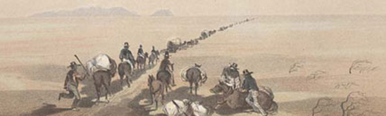
19th Century Survey Prints - About the Surveys

The United States and Mexican Boundary Survey (1848-1855) was an exploring expedition commissioned by the U.S. Congress and conducted under the auspices of the Department of the Interior by the U.S. Army Corps of Topographical Engineers. It determined the exact U.S.-Mexican border west of El Paso, Texas (the terminus point of the natural border provided by the Rio Grande River), after the conclusion of the U.S.-Mexican War (1846-1847). Prompted by vague wording in the Treaty of Guadalupe Hidalgo and the annexation of Texas several years earlier, the boundary survey was extended to include the Gadsden Purchase of 1853, and ultimately, by 1855, explored parts of Texas, New Mexico, and Arizona. Led by Major William Emory, the boundary survey also documented the resources of the land in question, recording the new territory’s geography, mission settlements, the flora and fauna, and the American Indian tribes, knowledge critical to fixing a beneficial boundary line for the United States. The survey’s findings were published in three volumes between 1857 and 1859.
The United States Naval and Astronomical Expedition to the Southern Hemisphere (1849-1852) was a scientific and exploring expedition commissioned by the U.S. Congress and conducted by the Department of the Navy to gather astronomical data in Santiago, Chile. The South American city’s map coordinates approximately mirror the latitude and longitude of the U.S. Naval Observatory in Washington, D.C. Corresponding observations of Mars and Venus in both the Southern and Northern Hemispheres were hoped to measure solar parallax and provide a definitive Earth-Sun distance by observing Mars and Venus. Though this was the expedition’s primary goal, leader Lieutenant James Gilliss dispatched Lieutenant Archibald MacRae to explore the area from Uspalatta Pass to Buenos Aires in 1852-1853, where he collected scientific and anthropological artifacts. The expedition’s findings were published in four volumes between the years 1855 and 1856.
The United States Pacific Railroad Surveys (1853-1855) were commissioned by the U.S. Congress and conducted by the U.S. Army Corps of Topographical Engineers to map routes for a transcontinental railroad line through what had become the American West. The competition of Congressional interests, relating to home constituencies, decided the many different exploratory routes. The surveys comprised several expeditions and routes from the central part of the country to the west, and north and south along the west coast. Some of the parallel (and horizontal) lines of latitude across the country were used as directional guides to the surveying expeditions. Along with topographic information about these routes the survey participants also prepared studies of the natural history and the ethnology of these areas. The survey findings were published in twelve volumes between 1855 and 1860 titled the Reports of Explorations and Surveys, to ascertain the most practicable and economical route for a railroad from the Mississippi River to the Pacific Ocean. The Pacific Railroad line, after the work of the surveys, ran close to the 38th parallel, through the center of the country.
"19th Century Survey Prints - About the Surveys" showing 4 items.
Chromolithograph of bird species "Euphonia Rufiventris adult male and Chlorophonia Occipitalis adulte male"
- Description
- Thomas Sinclair (c.1805–1881) of Philadelphia printed this chromolithograph of “Euphonia rufiventis [Vieill] adult male and Chlorophonia occipitalis [Du Bus] adult male,” now "Euphonia rufiventris" (Rufous-bellied euphonia) and "Chlorophonia occipitalis" (Blue-crowned chlorophonia), from an original sketch by William Dreser (c.1820–after 1860) of Philadelphia (1847–1860) and New York (1860). This is an unfinished proof, whose final version was published in 1855 by A.O.P. Nicholson in Washington, D.C. as Plate XXI in the “Birds” section of volume II of The United States Naval Astronomical Survey to the Southern Hemisphere, written by John Cassin (1813–1869).
- Location
- Currently not on view
- date of book publication
- 1855
- graphic artist
- Sinclair, Thomas
- original artist
- Dreser, William
- printer
- Nicholson, A. O. P.
- publisher
- United States Navy
- author
- Cassin, John
- Gilliss, James Melville
- ID Number
- 2008.0175.06
- accession number
- 2008.0175
- catalog number
- 2008.0175.06
- Data Source
- National Museum of American History, Kenneth E. Behring Center
Lithograph of "Indian Antiquities" pottery artifacts
- Description
- P.S. Duval and Company (c.1840s–1858) of Philadelphia printed this lithograph of “Indian Antiquities,” depicting South American woodenware, from an original sketch by John M. Stanley (1814–1872) of Detroit (1834–1840, 1864–1872) and Washington, D.C. (1850-1860). The illustration was published in 1855 by A.O.P. Nicholson in Washington, D.C. as Plate X in the “Indian remains” section of volume II of The United States Naval Astronomical Survey to the Southern Hemisphere, written by Thomas Ewbank (1792–1870).
- Location
- Currently not on view
- date made
- 1855
- original artist
- Wallis, O. J.
- Dreser, William
- Herbst, Francis
- graphic artist
- Sinclair, Thomas
- Dougal, William H.
- Duval, Peter S.
- printer
- Nicholson, A. O. P.
- publisher
- United States Navy
- original artist
- Richard, John H.
- Stanley, John Mix
- Siebert, Selmar
- author
- Cassin, John
- Ewbank, Thomas
- Baird, Spencer Fullerton
- Gilliss, James Melville
- ID Number
- 2007.0204.01
- accession number
- 2007.0204
- catalog number
- 2007.0204.01
- Data Source
- National Museum of American History, Kenneth E. Behring Center
Lithograph of bird species "Chrysomitris Marginalis"
- Description
- Thomas Sinclair (c.1805–1881) of Philadelphia printed this lithograph of “Chrysomitris Marginalis [Bonaparte] male and female," now "Carduelis barbata" or Black-chinned siskin, from an original sketch by William Dreser (c.1820–after 1860) of Philadelphia (1847–1860) and New York (1860). The illustration was published in 1855 by A.O.P. Nicholson in Washington, D.C. as Plate XVII in the “Birds” section of volume II of The United States Naval Astronomical Survey to the Southern Hemisphere, written by John Cassin (1813–1869).
- Location
- Currently not on view
- date made
- 1855
- graphic artist
- Sinclair, Thomas
- Dreser, William
- printer
- Nicholson, A. O. P.
- publisher
- United States Navy
- author
- Cassin, John
- Gilliss, James Melville
- ID Number
- 2008.0175.03
- accession number
- 2008.0175
- catalog number
- 2008.0175.03
- Data Source
- National Museum of American History, Kenneth E. Behring Center
Lithograph of bird species "Ericornis Melanura and Scytalopus Fuscus"
- Description
- Thomas Sinclair (c.1805–1881) of Philadelphia printed this chromolithograph of “Ericornis melanura [Gray] adult and Scytalopus fuscus [Gould],” now "Chilia melanura" (Crag chilia), and "Scytalopus fuscus" (Dusky tapaculo), from an original sketch by William Dreser (c. 1820–after 1860) of Philadelphia (1847–1860) and New York (1860). The illustration was published in 1855 by A.O.P. Nicholson in Washington, D.C. as Plate XXI in the “Birds” section of volume II of The United States Naval Astronomical Survey to the Southern Hemisphere, written by John Cassin (1813–1869).
- Location
- Currently not on view
- date of book publication
- 1855
- graphic artist
- Sinclair, Thomas
- original artist
- Dreser, William
- printer
- Nicholson, A. O. P.
- publisher
- United States Navy
- author
- Cassin, John
- Gilliss, James Melville
- ID Number
- 2008.0175.05
- accession number
- 2008.0175
- catalog number
- 2008.0175.05
- Data Source
- National Museum of American History, Kenneth E. Behring Center

