Measuring & Mapping

Where, how far, and how much? People have invented an astonishing array of devices to answer seemingly simple questions like these. Measuring and mapping objects in the Museum's collections include the instruments of the famous—Thomas Jefferson's thermometer and a pocket compass used by Meriwether Lewis and William Clark on their expedition across the American West. A timing device was part of the pioneering motion studies of Eadweard Muybridge in the late 1800s. Time measurement is represented in clocks from simple sundials to precise chronometers for mapping, surveying, and finding longitude. Everyday objects tell part of the story, too, from tape measures and electrical meters to more than 300 scales to measure food and drink. Maps of many kinds fill out the collections, from railroad surveys to star charts.

Nicolas Jansz Visscher (1618-1679), an accomplished Dutch cartographer, published an important map of the Dutch lands in North America. This is a copy of that map. The text at bottom center reads “A CORRECT COPY & IMITATION OF THE ORIGINAL DUTCH MAP in the possession of S.
Description
Nicolas Jansz Visscher (1618-1679), an accomplished Dutch cartographer, published an important map of the Dutch lands in North America. This is a copy of that map. The text at bottom center reads “A CORRECT COPY & IMITATION OF THE ORIGINAL DUTCH MAP in the possession of S. CONVERSE, PUBLISHER, NEW YORK. Engraved by THOS STARLING, WILMINGTON SQUARE, LONDON, 1833.” As in the Visscher original (which was actually published in 1655), an inset below the title depicts “NIEUW AMSTERDAM / op t’Eylant Manhattans.”
This map extends from 37° to 46°10' north latitude and from 297° to 312° longitude measured from west to east.
Sherman Converse, the one-time owner of the Visscher map, was a Yale graduate who was friendly with Noah Webster and published Webster's first dictionary. Converse moved from New York to Quebec in 1838, returned to the United States around 1844, and died in Boston.
Ref: Wilberforce Eames, “The First Three Engraved Views of New York,” New York Times (Feb. 16, 1901), p. BR 13.
Location
Currently not on view
date made
1833
ID Number
PH.317824
catalog number
317824
accession number
231759
Made by E. and G. W. Bartholomew in Bristol, Conn., about 1820, this clock features a thirty-hour wooden movement that strikes the hours.
Description
Made by E. and G. W. Bartholomew in Bristol, Conn., about 1820, this clock features a thirty-hour wooden movement that strikes the hours. The white-painted dial has Roman hour numerals, painted spandrels in gold and a central stylized ring of gold-painted designs inside the ring of hours. The mahogany case has a carved eagle splat, two hollow columns through which the weights fall, paw feet and three central parts: a clear glass door covers the dial, the center features a mirror and the bottom glass panel shows a reverse-painted scene with a structure and a tree inside a gold-leaf rectangle. Two weights and a brass-covered pendulum bob also survive. Inside the case, a printed label reads: "Patent Clocks Manufactured & Sold by E. & G. Bartholomew, Bristol, Conn. P. Canfield, Printer, Hartford.”
George Wells Bartholomew and his cousin Eli started a clockmaking business in Bristol, Conn., in 1828, and, when the partnership dissolved in a few short years, G. W. continued alone until 1840. He then opened a cutlery business, but abandoned it in 1848 to head to the California gold fields.
Reference:
Smith, Eddy N. et al., Bristol, Connecticut: “in the Olden Time New Cambridge,” which includes Forestville. Hartford, Conn.: City Printing, 1907.
Location
Currently not on view
date made
ca 1830
manufacturer
E. & G. Bartholomew
ID Number
ME.317039
catalog number
317039
accession number
233061
This astronomical instrument belonged to Columbia College (now University), and dates from around 1837. The horizontal and vertical circles are silvered, graduated to 10 minutes, and read by verniers to 10 sec. The insription reads "Troughton & Simms, London."Ref: Frederick W.
Description
This astronomical instrument belonged to Columbia College (now University), and dates from around 1837. The horizontal and vertical circles are silvered, graduated to 10 minutes, and read by verniers to 10 sec. The insription reads "Troughton & Simms, London."
Ref: Frederick W. Simms, A Treatise on the Principal Mathematical Instruments Employed in Surveying, Levelling, & Astronomy (Baltimore, 1844), pp. 89–109, describes a similar instrument, but with two vertical circles.
Location
Currently not on view
date made
ca 1837
maker
Troughton and Simms
ID Number
PH.323689
catalog number
323689
accession number
249200
Mercury-in-glass thermometer with a fairly large cylindrical bulb that could probably float in water.
Description
Mercury-in-glass thermometer with a fairly large cylindrical bulb that could probably float in water. An auxiliary glass tube attached to the stem holds a hand-written piece of paper marked “Thermometre Selon Fahrenheit et Decimal par Pixii rue du Jardinet N° 2 A Paris.” This paper also carries two parallel scales. One extends from -30 to +127 graduated every degree, with indications for “Glace Tempere” at zero and “Eau Bte” at 100. The other extends from -22 to +260, graduated every 2 degrees.
This thermometer was made between 1818 and 1838 when Pixii worked at rue du Jardinet N° 2. It may have belonged to the American scientist, John William Draper.
Location
Currently not on view
date made
1818-1838
maker
Maison Pixii
ID Number
PH.333986
accession number
304826
catalog number
333986
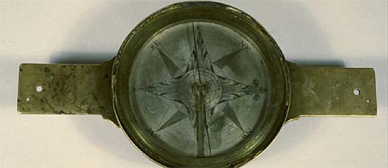
This compass is marked "Meneely & Oothout, West Troy, N.Y." It was made in 1837, and the word "Warranted" indicates a guarantee of quality.
Description
This compass is marked "Meneely & Oothout, West Troy, N.Y." It was made in 1837, and the word "Warranted" indicates a guarantee of quality. It has a variation arc on the south arm that extends 30 units either way; the vernier is moved by a heavy tangent screw on top of the south arm, and reads to 2 minutes. There are two levels on the north arm. The compass was originally owned by Joseph Ham, a surveyor in Dutchess County, New York.
Andrew Meneely (1802–1851) apprenticed with Julius Hanks, learning to cast bells and manufacture mathematical instruments. Returning to West Troy, N.Y., where he was born, Meneely established a successful brass foundry. In 1834 he advertised "Leveling and Surveying Instruments" as well as clocks and church bells. Meneely joined in partnership with Jonas V. Oothout (1814–1860) in January 1836, offering church bells, town clocks, theodolites, levels, and surveyor’s compasses of all kinds. The Meneely & Oothout partnership ended in 1838. Meneely then continued his business, taking his eldest son into partnership in 1849.
Ref: Conrad S. Ham, "A Family History of a Group of Surveying Instruments 1750 to the Present Year 1954," Annual Report of Proceedings of the Connecticut Society of Civil Engineers 70 (1954): 134-138.
Location
Currently not on view
date made
1837
owner
Ham, Joseph
maker
Meneely and Oothout
ID Number
1983.0548.02a
accession number
1983.0548
catalog number
1983.0548.02a
The "Merrill & Davis New York" inscription indicates that this compass dates from the period 1835-1837 when Robert Merrill and William C. Davis worked together in New York City. There are two level vials on the north arm.
Description
The "Merrill & Davis New York" inscription indicates that this compass dates from the period 1835-1837 when Robert Merrill and William C. Davis worked together in New York City. There are two level vials on the north arm. The decoration on the face (a circle of leaves) is a typical feature of New York compasses. The "Wiltberger, City of Washington, D.C." inscription on the bottom of the wooden box must be that of the merchant, Charles H. Wiltberger (1798-1872).
Location
Currently not on view
date made
1835-1837
maker
Merrill and Davis
ID Number
PH.333620
accession number
303443
catalog number
333620
This instrument is a specialized timekeeper designed for finding longitude at sea. Its form is that of the standardized 19th-century marine chronometer. It was transferred to the Smithsonian from the U.S. Coast & Geodetic Survey.
Description
This instrument is a specialized timekeeper designed for finding longitude at sea. Its form is that of the standardized 19th-century marine chronometer. It was transferred to the Smithsonian from the U.S. Coast & Geodetic Survey. John Roger Arnold, son of chronometer maker John Arnold, and Edward John Dent (1790-1853) were in business together from 1830-1840 at 84 Strand, London. Charles Frodsham took over Arnold’s business after Arnold’s death in 1843. E. J. Dent, who had started making chronometers in 1814, continued in business until his death, when others continued the firm under various names and at various addresses. The business continues today.
Mechanism details:
Escapement: Earnshaw, spring detent
Duration: 48-hour
Power source: Spring drive with chain and fusee
Balance spring: helical, blued steel
Winding key, stamped "1131"
Bowl details:
Brass bowl, fitted with a sprung cylindrical inner bowl as a dust cover (original work); "1131" stamped on bottom inside of bowl
Dimensions: 4.17" dia. across bezel x 2.7"
Brass fittings, brass gimbal
Bezel screwed and milled
Crystal convex, plain
Dial details:
Engraved and silvered brass
Indicates hours, minutes, seconds, winding level up and down
Inscription: "ARNOLD & DENT, / 84. Strand, London No 1131”
Hands: Gold, spade, with blued steel seconds hand
Case details:
Mahogany
Three-part, glazed center section
Brass side handles and escutcheon
Bone roundel at front
Inscriptions: "1131" engraved on roundel on case. "U.S.C.S." engraved on case lid
References:
1. Gould, Rupert T. The Marine Chronometer. London: Holland Press, 1960.
2. Mercer, Tony. Chronometer Makers of the World. Essex: NAG Press, 1991.
3. Mercer, Vaudrey. John Arnold & Son. London: Antiquarian Horological Society, 1972.
4. Mercer, Vaudrey. Edward John Dent and His Successors. London: Antiquarian Horological Society, 1977.
5. Whitney, Marvin E. The Ship's Chronometer. Cincinnati: American Watchmakers Institute Press, 1985.
Location
Currently not on view
date made
1839
manufacturer
Arnold & Dent
ID Number
ME.314612
catalog number
314612
accession number
206050
This map, created under the auspices of the General Land Office, divided Illinois into square townships 6 miles on each side (though townships at the edges of the state tend to be smaller and irregular in shape). The scale is 18 miles to the inch.
Description
This map, created under the auspices of the General Land Office, divided Illinois into square townships 6 miles on each side (though townships at the edges of the state tend to be smaller and irregular in shape). The scale is 18 miles to the inch. The identified towns include Alton, Chicago, Danville, Edwardsville, Galena, Kaskaskia, Palestine, Quincy, Shawneetown, and Springfield, as well as St. Louis in the Missouri Territory, and Vincennes in Indiana. The 3d Principal Meridian runs down the middle of the state. The 4th Principal Meridian lies about 66 miles to the west. The text at bottom left reads “Surveyor Generals Office / Saint Louis 1st October 1839” and “William Milburn /Surveyor General.”
Ref: William Milburn, “Report,” in Public Documents Printed by Order of the Senate of the United States (Washington, D.C., 1841), vol. 3, pp. 57-109.
C. Albert White, A History of the Rectangular Land Survey System (Washington, D.C., 1983).
Location
Currently not on view
date made
1839
ID Number
PH.317492
accession number
230397
catalog number
317492
An engine indicator is an instrument for graphically recording the cylinder pressure versus piston displacement through an engine stroke cycle. Engineers use the resulting diagram to check the design and performance of the engine.
Description
An engine indicator is an instrument for graphically recording the cylinder pressure versus piston displacement through an engine stroke cycle. Engineers use the resulting diagram to check the design and performance of the engine. This type of indicator was invented by John McNaught of Glasgow, Scotland ca 1825. This particular unit was manufactured by Novelty Iron Works of New York around 1842.
The McNaught indicator was a significant improvement over the original Watt indicator which made steam-pressure diagrams on a flat piece of recording paper. The piston of the engine under test moved the paper horizontally, and the indicator’s piston moved the paper vertically in proportion to the pressure in the cylinder. McNaught’s improvement was the introduction of an oscillating drum which held the recording paper. The indicator is made of brass and consists of a cylinder and piston with internal spring and the separate recording drum. The piston causes the stylus to rise and fall with pressure changes in the engine under measurement thereby directly recording the indicator’s output on the paper. Around the drum’s base is wound a cord that is attached to the connecting rod of the piston on the steam engine being measured. This causes the drum to rotate as the engine’s piston moves. An internal coil spring causes the cord to retract and the drum to counterrotate back to its original position as the connecting rod returns. The result is a steam pressure-volume diagram which is used to measure the efficiency and other attributes of the steam engine.
The introduction of the steam indicator in the late 1790s and early 1800s by James Watt and others had a great impact on the understanding of how the steam behaved inside the engine's cylinder and thereby enabled much more exacting and sophisticated designs. The devices also changed how the economics and efficiency of steam engines were portrayed and marketed. They helped the prospective owner of a machine better understand how much his fuel costs would be for a given amount of work performed.
Measurement of fuel consumed and work delivered by the engine was begun by Watt, who in part justified the selling price of his engines on the amount of fuel cost the purchaser might save compared to an alternate engine. In the early days of steam power, the method to compare engine performance was based on a concept termed the engine’s “duty”. It originally was calculated as the number of pounds of water raised one foot high per one bushel of coal consumed. The duty method was open to criticism due to its inability to take into consideration finer points of efficiency in real world applications of engines. Accurate determination of fuel used in relation to work performed has been fundamental to the design and improvement of all steam-driven prime movers ever since Watt’s time. And, the steam indicators’ key contribution was the accurate measurements of performance while the engine was actually doing the work it was designed to do.
date made
ca 1825 - 1830
ID Number
MC.307516
accession number
68187
catalog number
307516
Joseph Ives—a Bristol, Connecticut clockmaker notable for his inventiveness but lack of business success—first introduced wagon-spring clocks in the 1820s. This example dates from about 1825, when he was working in Brooklyn, N.Y.
Description
Joseph Ives—a Bristol, Connecticut clockmaker notable for his inventiveness but lack of business success—first introduced wagon-spring clocks in the 1820s. This example dates from about 1825, when he was working in Brooklyn, N.Y. Ives’ wagon-spring clocks had conventional brass movements, except for one feature: the strings that ordinarily would have held the weights were connected, through intermediary pulleys, to the free ends of what looked like a leafed wagon-spring on the bottom of the case.
Ives resorted to his wagon spring because coiled steel springs—common on European clocks—were not produced in the United States until the middle of the nineteenth century and the introduction of the Bessemer process for mass-producing steel.
Reference:
Kenneth Roberts, The Contributions of Joseph Ives to Connecticut Clock Technology 1810-1862 (Bristol, Conn.: American Clock and Watch Museum, 1970).
Location
Currently not on view
date made
1825-1830
maker
Ives, Joseph
ID Number
1984.0416.032
catalog number
1984.0416.032
accession number
1984.0416
“WILSON’S / NEW THIRTEEN INCH / CELESTIAL GLOBE / Containing the positions of nearly 7000 / Stars, Clusters, Nebulae & Carefully compil’d / & laid down from the latest & most approv’d / astronomical tables reduced to the present / time / By C.
Description
“WILSON’S / NEW THIRTEEN INCH / CELESTIAL GLOBE / Containing the positions of nearly 7000 / Stars, Clusters, Nebulae & Carefully compil’d / & laid down from the latest & most approv’d / astronomical tables reduced to the present / time / By C. LANCASTER / 1835 / ALBANY ST N.Y.”
This globe has a 4-leg wooden base, a wooden horizon circle and a brass meridian.
James Wilson (1763-1855) was America’s first commercial globe maker. He was self-taught in geography and the techniques of engraving, but his globes were accurate, beautiful, and a commercial success. He made his first globes in Vermont around 1810 and established an “artificial globe manufactory” in Albany in 1818. Cyrus Lancaster joined the firm in 1826, took charge of the business after the death of Wilson’s sons in 1833, and introduced this version of the 13-inch celestial globe soon thereafter.
Ref: D. J. Warner, “The Geography of Heaven and Earth,” Rittenhouse 2 (1988): 135-137.
Location
Currently not on view
date made
1835
associated person
Wilson, James
maker
Lancaster, Cyrus
ID Number
PH.326969
accession number
263804
catalog number
326969
“WILSON’S / NEW AMERICAN THIRTEEN INCH / TERRESTRIAL GLOBE / Exhibiting with the greatest possible Accuracy, / THE POSITIONS OF THE PRINCIPAL KNOWN / PLACES OF THE EARTH; / WITH the Tracks of various Circumnavigators together with / New Discoveries and Political Alterations down
Description
“WILSON’S / NEW AMERICAN THIRTEEN INCH / TERRESTRIAL GLOBE / Exhibiting with the greatest possible Accuracy, / THE POSITIONS OF THE PRINCIPAL KNOWN / PLACES OF THE EARTH; / WITH the Tracks of various Circumnavigators together with / New Discoveries and Political Alterations down to / THE present PERIOD: 1835 / By CYRUS LANCASTER / 1835 / ALBANY, N.Y. / S. Wood & Sons Agents N. York.” Other inscriptions read: “D.W. Wilson dd.” and “Balch, Rawdon & Co. fet.” An allegorical image shows a woman (Columbia) holding dividers and a globe marked “AMERICA,” and an eagle holding a banner marked “E PLURIBUS UNUM.”
This globe is supported on a 4-leg wooden base, and provided with a wooden horizon circle and a brass meridian.
James Wilson (1763-1855) was America’s first commercial globe maker. He was self-taught in geography and the techniques of engraving, but his globes were accurate, beautiful, and a commercial success. Wilson made his first globes in Vermont around 1810, and established an “artificial globe manufactory” in Albany in 1818. His son, David W. Wilson, drew the maps for these later globes. The firm of Balch, Rawdon & Co. printed the maps. Cyrus Lancaster joined Wilson’s firm in 1826, took charge of the business after the death of Wilson’s sons in 1833, and introduced this version of the 13-inch terrestrial globe soon thereafter.
Ref: D. J. Warner, “The Geography of Heaven and Earth,” Rittenhouse 2 (1999): 135-137.
Location
Currently not on view
date made
ca 1835
maker
Lancaster, Cyrus
ID Number
PH.326970
accession number
263804
catalog number
326970
The cartouche in the north Pacific reads “CARY’S / NEW / TERRESTRIAL GLOBE, / Drawn from the most recent / GEOGRAPHICAL WORKS / shewing the whole of the New Discoveries / with the / TRACKS of the PRINCIPAL NAVIGATORS / and every improvement in Geography / to the present Time.
Description
The cartouche in the north Pacific reads “CARY’S / NEW / TERRESTRIAL GLOBE, / Drawn from the most recent / GEOGRAPHICAL WORKS / shewing the whole of the New Discoveries / with the / TRACKS of the PRINCIPAL NAVIGATORS / and every improvement in Geography / to the present Time. / LONDON: / London Published by G. & J. Cary, St James’s St Jan. 7th 1838”
A water mark on the map gores reads “C WILMOT / 1837”
The globe is held in a 4-legged wooden stand, with a wooden horizon circle and a brass meridian.
John Cary was a globe maker in London who began in business in 1791. He introduced his new 12-inch terrestrial globe, and the celestial mate, in 1798. This example is dated 1838. The signature refers to John Cary’s sons, George and John Jr., who worked together from around 1820 to 1852.
Ref: Herbert George Fordham, John Cary: Engraver, Map, Chart and Print-Seller and Globe-Maker, 1754 to 1835 (Cambridge, 1925)
Location
Currently not on view
date made
1838
ID Number
PH.392869B
catalog number
392869B
accession number
214358
The frame of this instrument is rosewood, while the arcs, cross bar, and sights are boxwood.
Description
The frame of this instrument is rosewood, while the arcs, cross bar, and sights are boxwood. The boxwood inset is inscribed "Made.by.John.Holbeche.for Capt Joseph.Swan.1738." John Holbeche advertised an Instrument Maker & Ship-Chandler at the Corner of the Hermitage in London.
Ref: Gloria Clifton, Directory of British Scientific Instrument Makers 1550-1851 (London, 1995), p. 138.
Location
Currently not on view
date made
1738
maker
John Holbeche
ID Number
PH.318439
catalog number
318439
accession number
234475
Edward Troughton, a prominent instrument maker in London, introduced this type of reflecting circle in 1796. The telescope, mirror, and filters are on one side of the circle, while the silver scale is on the other.
Description
Edward Troughton, a prominent instrument maker in London, introduced this type of reflecting circle in 1796. The telescope, mirror, and filters are on one side of the circle, while the silver scale is on the other. The scale is graduated to 20 minutes, and read by three verniers (one has a tangent screw) to 20 seconds. The circle is supported on a heavy brass stand with a counterweight. The inscription reads "Troughton & Simms 240 LONDON." This example belonged to Worcester Polytechnic Institute, and was probably made in the late 1830s. Troughton & Simms was still offering instruments of this sort in the 1850s–at a cost of £23.
Ref: Abraham Rees, The Cyclopaedia; or, Universal Dictionary of Arts, Sciences, and Literature (London, 1819), vol. 8, art. "Circle," and Plate III of "Astronomical Instruments."
"Directions for observing with Troughton’s Reflecting Circle," quoted in F. W. Simms, A Treatise on the Principal Mathematical Instruments (Baltimore, 1836), pp. 51-54.
"Catalogue of Instruments Made By Troughton & Simms," appended to William Simms, The Achromatic Telescope (London, 1852).
Location
Currently not on view
date made
late 1830s
maker
Troughton and Simms
ID Number
1987.0924.01
catalog number
1987.0924.01
accession number
1987.0924

Our collection database is a work in progress. We may update this record based on further research and review. Learn more about our approach to sharing our collection online.

If you would like to know how you can use content on this page, see the Smithsonian's Terms of Use. If you need to request an image for publication or other use, please visit Rights and Reproductions.