Measuring & Mapping

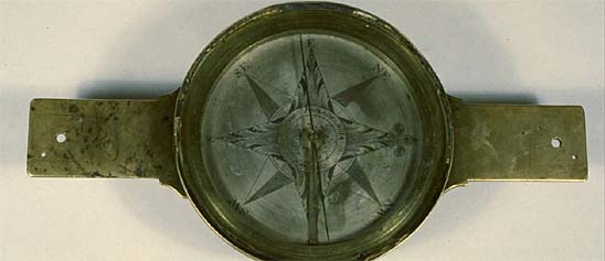
Where, how far, and how much? People have invented an astonishing array of devices to answer seemingly simple questions like these. Measuring and mapping objects in the Museum's collections include the instruments of the famous—Thomas Jefferson's thermometer and a pocket compass used by Meriwether Lewis and William Clark on their expedition across the American West. A timing device was part of the pioneering motion studies of Eadweard Muybridge in the late 1800s. Time measurement is represented in clocks from simple sundials to precise chronometers for mapping, surveying, and finding longitude. Everyday objects tell part of the story, too, from tape measures and electrical meters to more than 300 scales to measure food and drink. Maps of many kinds fill out the collections, from railroad surveys to star charts.

William Blaeu's decorative map, made about 1648, includes oval vignettes of Latin American cities and harbors along the top border. Paired examples of different native peoples line either side, including the King and Queen of Florida shown in the detail.
Description
William Blaeu's decorative map, made about 1648, includes oval vignettes of Latin American cities and harbors along the top border. Paired examples of different native peoples line either side, including the King and Queen of Florida shown in the detail. The map represents contemporary geographical understanding of the New World, together with sea monsters and other imaginative features.
Many maps of the Americas were produced during the period of exploration and colonial settlement in the 17th century. The period between 1630 and 1700 is known as the golden age of Dutch cartography, as the Netherlands was a center for map publishing as well as for the country's maritime enterprise that depended on maps and charts.
The Museum's map collection includes a number of important examples received as a gift from Mabel Brady Garvan, who, with her husband Francis P. Garvan, built an important collection of American paintings, furniture, and decorative arts that is now at the Yale University Art Gallery.
Location
Currently not on view
Date made
ca 1648
graphic artist
Blaeu, William
ID Number
GA.24335
accession number
251493
catalog number
24335
This small,,square paper instrument is the oldest surviving Anglo-American star map. It was drawn by hand in 1780 by Simeon de Witt, geographer to George Washington and the Continental army.
Description
This small,,square paper instrument is the oldest surviving Anglo-American star map. It was drawn by hand in 1780 by Simeon de Witt, geographer to George Washington and the Continental army. It shows the bright stars visible in Ringwood, New Jersey, where he was stationed.
The upper section of the instrument consists of three parts. The topmost is a rotating disc with an oval cut out of it. The four cardinal points are indicated on the oval. The edge is divided to degrees, with every 10 degrees marked. Below the oval opening is a perpetual calendar for the years 1781 to 1826. This is labeled: 1780 (/) Simeon DeWitt fecit. (/) The Days of the Months for ever. Below the top disc is a rotating disc, attached to the base, that has a star map on it. The map shows first through fifth magnitude stars (first magnitude stars are indicated by a seven-pointed star, second magnitude by a six-pointed star, 3rd magnitude by a five-pointed star, fourth magnitude by a x and fifth magnitude by a dot). Stars are arranged in constellations. In additiion to Ptolemaic constellations, the constellations Lynx, Columba Noachi, Leo Min, Monocerus, Camelopardalis, Mons Menalus, and Antonius are represented. The 1596 Nova in Cetus and the Via Lactea also are shown. The ecliptic, polar circle, Tropic of Cancer, equator, and Tropic of Capricorn are represented by circles. The edge of the disc has two scales, one of days of the year and the second of degrees of the zodiac.
The third part of the instrument is a square base marked at the top "ASTROLABE FOR Lat. 41." On the left side is a list of sixteen stars of first magnitude. On the right is a list of the constellations that contain these stars. The reverse of the base contains a disc allowing one to determine phases of the moon for dates from 1781 to 1834.
Reference:
P.A. Kidwell, "The astrolabe for latitude 41°N of Simeon de Witt: an early American celestial planisphere," Imago Mundi, 2009, 61, pp. 91-96.
Location
Currently not on view
Date made
1780
maker
De Witt, Simeon
ID Number
MA.333591
catalog number
333591
accession number
1987.0763
Albert Boschke (b. 1823) was a German-born civil engineer who served as a draftsman for the U.S. Coast Survey. Realizing that there was no modern map of the District of Columbia, he organized a team of surveyors to rectify this situation.
Description
Albert Boschke (b. 1823) was a German-born civil engineer who served as a draftsman for the U.S. Coast Survey. Realizing that there was no modern map of the District of Columbia, he organized a team of surveyors to rectify this situation. Boschke’s first map of the area, done on his own time and with his own funds, was published in 1857.
An improved map was in the hands of the printer in 1861 when the Civil War broke out and Boschke was stationed in Boston. Fearing an attack by Confederate forces, the U.S. Army seized the copper plates and printed maps from the printers, and eventually paid them about $8,500 for this material. Many years later, living in California and in need of money, Boschke asked Congress to pay $25,000 for his property. Although Congress granted his petition, the money did not appear. Boschke sued the government but to no avail.
This is a reduced version of the Boschke map, with “COUNTY ROADS AS CORRECTED TO 1880.” We have not determined who published it.
Ref: Marcus Baker, “Surveys and Maps of the District of Columbia,” National Geographic 6 (November 1, 1894): 149-178, on 156-158.
Wilhemus Bogart Bryan, Bibliography of the District of Columbia (Washington, D.C., 1900), p. 121.
“A. Boschke v. the United States,” in Cases Decided in the Court of Claims of the United States 44 (1910): 397-408.
Location
Currently not on view
ID Number
PH.317490
accession number
230397
catalog number
317490
P. S. Duval and Company (ca 1840s-1858) of Philadelphia produced this chromolithographic print from an original illustration by John M. Stanley (1814-1872).
Description (Brief)
P. S. Duval and Company (ca 1840s-1858) of Philadelphia produced this chromolithographic print from an original illustration by John M. Stanley (1814-1872). The image of "Wooden Ware, etc." was published as Plate X in Volume 2, following page 116 of Appendix E (Indian Antiquities) by Thomas Ewbank (1792-1870) in the report describing "The U.S. Naval Astronomical Expedition to the Southern Hemisphere during the Years 1849, 1850, 1851, and 1852" by James M. Gillis (1811-1865). The volume was printed in 1855 by A. O. P. Nicholson (1808-1876) of Washington, D.C.
Location
Currently not on view
date made
1855
original artist
Wallis, O. J.
Dreser, William
Herbst, Francis
graphic artist
Sinclair, Thomas
Dougal, William H.
Duval, Peter S.
printer
Nicholson, A. O. P.
publisher
United States Navy
original artist
Richard, John H.
Stanley, John Mix
Siebert, Selmar
author
Cassin, John
Ewbank, Thomas
Baird, Spencer Fullerton
Gilliss, James Melville
ID Number
2007.0204.01
accession number
2007.0204
catalog number
2007.0204.01
This Both’s patent section liner and scale divider was manufactured by Keuffel & Esser Company, New York. Adolph Both of Portland, Maine was issued patent no. 393,290 on November 20, 1888, for section liner improvements.
Description
This Both’s patent section liner and scale divider was manufactured by Keuffel & Esser Company, New York. Adolph Both of Portland, Maine was issued patent no. 393,290 on November 20, 1888, for section liner improvements. In the 1909 K&E catalog the instrument was item #1159 and sold for $12.00 (equivalent to about $303 in 2019). The instrument is made primarily of brass and steel. It consists of a carriage and a rack bar which slides under the carriage. The carriage has a semi-circular protractor, a ruler arm, and a mechanism that engages the teeth of the rack bar. The slide and ruler arm advance on the rack bar by pressing on a knob, taking from one to six teeth at a time according how the adjusting nut is set.
When not in use the instrument is stored in a varnished wooden box with hinges and a locking clasp. The exterior of the lid is stamped in black with the product name and the company’s information. The interior of the box has a velvet lined bottom and is fitted to secure the instrument. The underside of the lid has a printed label with instructions and a list of commonly used angles.
Draftsmen used this tool to draw precise parallel lines, a means of producing shading. This section liner was used by a map maker in Buffalo, NY prior to 1960.
References:
Keuffel and Esser Company, Catalogue, New York; Keuffel & Esser, 1909, p. 163.
Accession File
Location
Currently not on view
maker
Keuffel & Esser Co.
ID Number
2018.0283.01
accession number
2018.0283
catalog number
2018.0283.01
This engraved woodblock of the “Earliest map showing [the] location of the Cherokees, 1597” was prepared by the Government Printing Office in Washington, D.C.; the image was published as Plate VII (p.128) in an article by Charles Royce (1845-1923) entitled “The Cherokee Nation of
Description
This engraved woodblock of the “Earliest map showing [the] location of the Cherokees, 1597” was prepared by the Government Printing Office in Washington, D.C.; the image was published as Plate VII (p.128) in an article by Charles Royce (1845-1923) entitled “The Cherokee Nation of Indians: a narrative of their official relations with the colonial and federal governments” in the Fifth Annual Report of the Bureau of Ethnology to the Secretary of the Smithsonian, 1883-84.
Location
Currently not on view
date made
1887
publisher
Government Printing Office
Bureau of American Ethnology
printer
U.S. Government Printing Office
author
Royce, Charles C.
block maker
J. J. & Co.
ID Number
1980.0219.1531
catalog number
1980.0219.1531
accession number
1980.0219

Our collection database is a work in progress. We may update this record based on further research and review. Learn more about our approach to sharing our collection online.

If you would like to know how you can use content on this page, see the Smithsonian's Terms of Use. If you need to request an image for publication or other use, please visit Rights and Reproductions.