Measuring & Mapping

Where, how far, and how much? People have invented an astonishing array of devices to answer seemingly simple questions like these. Measuring and mapping objects in the Museum's collections include the instruments of the famous—Thomas Jefferson's thermometer and a pocket compass used by Meriwether Lewis and William Clark on their expedition across the American West. A timing device was part of the pioneering motion studies of Eadweard Muybridge in the late 1800s. Time measurement is represented in clocks from simple sundials to precise chronometers for mapping, surveying, and finding longitude. Everyday objects tell part of the story, too, from tape measures and electrical meters to more than 300 scales to measure food and drink. Maps of many kinds fill out the collections, from railroad surveys to star charts.

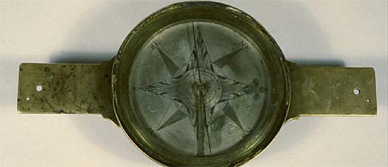
Like many surveyor's compasses made in New York in the first half of the 19th century, this one has an ornate floral design on its face. Unlike most American compasses of the period, however, the face reads clockwise, and there is no maker's signature.
Description
Like many surveyor's compasses made in New York in the first half of the 19th century, this one has an ornate floral design on its face. Unlike most American compasses of the period, however, the face reads clockwise, and there is no maker's signature. The donor believed that James Griswold used this compass and the associated chain, pins, tally, and drawing instruments while laying out the New York and Erie Railroad.
Location
Currently not on view
date made
ca 1800-1850
ID Number
PH.319340
catalog number
319340
accession number
236805
The Utah Territory was organized in September 1850, on the same day that California became a state. As large numbers of migrants traveling to California led to increased hostilities with Mormon settlers, the U.S. Army sent men into the region. James H. Simpson (b.
Description
The Utah Territory was organized in September 1850, on the same day that California became a state. As large numbers of migrants traveling to California led to increased hostilities with Mormon settlers, the U.S. Army sent men into the region. James H. Simpson (b. 1813), a graduate of the U.S. Military Academy who served with the Topographical Engineers, arrived in Utah in 1858 and began conducting a reconnaissance for a new route to California. He drew this map later that year, after winter weather precluded further work in the field. The map extends from 34° to about 44° latitude, and from below 105° to about 122° longitude west of Greenwich.
Simpson based the geography of this map on maps drawn by John C. Frémont (1848), H. Stansbury and J. W. Gunnison (1849), Gunnison (1853), E. G. Beckworth (1854), R. S. Williamson and J. G. Parke (1854), and J. Kirke (1857). He included wagon roads, proposed roads, and the routes taken by Fremont, Stansbury and Gunnison, and Gunnison and Beckworth. Lake Tahoe is here named Lake Bigler in honor of John Bigler, the third governor of California.
Location
Currently not on view
date made
1858
ID Number
PH.317496
accession number
230397
catalog number
317496
This mercury-in-glass thermometer has a bend in the stem that accommodates a rolled piece of paper on which is written, in ink: “Thermometer nach Réaumur & Fahrenheit.” The left side of the scale extends from -32 to +55, graduated by degrees Réaumur, with “E.P.” (German for ice p
Description
This mercury-in-glass thermometer has a bend in the stem that accommodates a rolled piece of paper on which is written, in ink: “Thermometer nach Réaumur & Fahrenheit.” The left side of the scale extends from -32 to +55, graduated by degrees Réaumur, with “E.P.” (German for ice point) at zero; the right side extends from -40 to +150, graduated every two degrees Fahrenheit. The whole is enclosed in an outer glass casing.
Location
Currently not on view
date made
ca 1800-1850
ID Number
PH.316459
catalog number
316459
accession number
223721
This is one of the earliest watch movements manufactured in the United States. Made at what eventually became the Waltham Watch Company, it is part of the firm’s third run of watches in Roxbury, Massachusetts, about 1853.
Description
This is one of the earliest watch movements manufactured in the United States. Made at what eventually became the Waltham Watch Company, it is part of the firm’s third run of watches in Roxbury, Massachusetts, about 1853. The movement bears the serial number 531 and the name Samuel Curtis, one of the firm’s first investors.
In the 1850s, watchmakers at the firm began to develop the world's first mass-produced watches. They completely redesigned the watch so that its movement could be assembled from interchangeable parts made on special machines. They also developed a highly organized factory-based work system to speed production and cut costs of watches. Although it would be well into the 20th century before the watch industry achieved a very high level of interchangeability, the Waltham designers started the innovations that would eventually lead there.
Launched in 1849 in a corner of the Howard & Davis clock factory in Roxbury, Massachusetts, the company’s early years were financially unsteady. The company name changed repeatedly as investors came and went. Operations moved from Roxbury to Waltham in 1854, where the company settled, optimistically poised for expansion, on a tract of land with nearly 100 acres. The watchmakers at Waltham helped spawn an American industry that by 1880 had ten firms making nearly three million watches a year.
Details:
Movement: spring going-barrel, full plate, gilt finish, 18 size, 15 jewels, key wound at back and key set at front, steel three-armed balance, lever escapement, regulator with index on back plate; marked: “Roxbury/ No. 531/ Samuel Curtis”
Dial: White enamel dial, Roman numerals, black hands (minute hand is replacement), separate seconds at 6
References:
Henry G. Abbott, History of the American Waltham Watch Company (Chicago: American Jeweler Print, 1905).
Charles Moore, Timing a Century: History of the Waltham Watch Company (Cambridge, Mass.: Harvard University Press, 1945).
Donald Hoke, Ingenious Yankees: The Rise of the American System of Manufactures in the Private Sector (New York: Columbia University Press, 1990).
Location
Currently not on view
date made
1853
maker
Howard & Davis
ID Number
ME.222557
catalog number
222557
accession number
41705
This is a standard theodolite as made by Troughton & Simms in the second quarter of the 19th century. The horizontal circle is silvered, graduated to 20 minutes, and read by two verniers with magnifiers to 20 seconds. The vertical arc is graduated and read in a similar manner.
Description
This is a standard theodolite as made by Troughton & Simms in the second quarter of the 19th century. The horizontal circle is silvered, graduated to 20 minutes, and read by two verniers with magnifiers to 20 seconds. The vertical arc is graduated and read in a similar manner. The scale "Diff. of Hypo. & Base" that appears on the back of the vertical arc is used to correlate the angle of elevation or depression with horizontal distances when surveying sloping ground. The instrument is marked "Troughton & Simms LONDON" and "No. 1" (which was probably added by a former owner).
Location
Currently not on view
date made
1825-1850
maker
Troughton and Simms
ID Number
PH.330222
catalog number
330222
accession number
288699
Invented in the 1660s by Robert Hooke, the "curator of experiments" in the new Royal Society of London, the “wheel” or “banjo” barometer has a tube that is bent into a J shape; a float, sitting on the shorter end of the tube, connects with a circular scale that is large and easil
Description
Invented in the 1660s by Robert Hooke, the "curator of experiments" in the new Royal Society of London, the “wheel” or “banjo” barometer has a tube that is bent into a J shape; a float, sitting on the shorter end of the tube, connects with a circular scale that is large and easily read. Barometers of this sort have long been popular for domestic use. This example is marked “D. Fagioli & Son, 39 Warner St Clerkenwell” and was made in London, perhaps in the 1840s. The dial reads from 28 to 31 inches of mercury. In addition to the barometer itself, there is a twisted gut hygrometer, a spirit thermometer, and a convex mirror. The Taylor Instrument companies gave it to the Smithsonian in 1923.
Location
Currently not on view
date made
ca 1839-1854
maker
Dominic Fagioli & Son
ID Number
PH.308173
accession number
70532
catalog number
308173
The compass has a brass bowl gimbal mounted in a wooden box with a paper card made for Robert Ludlow Shaw. The inscription in the center of the card reads "R. L. SHAW * 222 WATER ST NEW-YORK*."The box is marked "J.
Description
The compass has a brass bowl gimbal mounted in a wooden box with a paper card made for Robert Ludlow Shaw. The inscription in the center of the card reads "R. L. SHAW * 222 WATER ST NEW-YORK*."
The box is marked "J. BELL’S PATENT JANY 25, 1853." This refers to John Bell of New York City who designed a method of joining the corners of wooden boxes.
Ref: John Bell, "Method of Joining Corners of Boxes, &c." U.S. Patent #9,552 (1853).
Location
Currently not on view
date made
after 1853
maker
Shaw, Robert Ludlow
ID Number
PH.327635
catalog number
327635
accession number
268279
This engraved printing plate was prepared to print an image of "Ptilonopus Perousei" (now Many-colored Fruit Dove, Ptilinopus perousii Peale (S.
Description (Brief)
This engraved printing plate was prepared to print an image of "Ptilonopus Perousei" (now Many-colored Fruit Dove, Ptilinopus perousii Peale (S. polynesia)) for the publication "United States Exploring Expedition, During the Years 1838, 1839, 1840, 1841, 1842," Volume 8, Mammalogy and Ornithology, plate 33, in the edition Philadelphia : J. B. Lippincott & Co., 1858. The engraving was produced by Robert Hinshelwood after T. R. Peale.
Description
Robert Hinshelwood (1812–after 1875) of New York City engraved this copper printing plate after a drawing by Expedition Naturalist Titian Ramsey Peale. The image depicts the Ptilonopus Perousei (now Many-colored Fruit Dove, Ptilinopus perousii Peale [S. polynesia]). The engraved illustration was published as Plate 33 in Volume VIII, Mammalogy and Ornithology, by John Cassin, 1858.
Location
Currently not on view
Date made
1858
publisher
Wilkes, Charles
original artist
Peale, Titian Ramsay
graphic artist
Hinshelwood, Robert
printer
Sherman, Conger
author
Cassin, John
ID Number
1999.0145.413
catalog number
1999.0145.413
accession number
1999.0145
The double-framed brass sextant was patented by Edward Troughton in London in 1788, and the form remained popular throughout the first half of the 19th century.
Description
The double-framed brass sextant was patented by Edward Troughton in London in 1788, and the form remained popular throughout the first half of the 19th century. This example belonged to Haverford College in Pennsylvania and may have been acquired when that school was founded in 1833. It has a silvered scale that is graduated every 10 minutes from -5° to +145° and read by vernier with tangent screw and swinging magnifier. The inscription reads "W. & S. Jones Holborn London."
Ref: Edward Troughton, "Framing to be used in the construction of octants, sextants, and quadrants," British patent #1644.
Location
Currently not on view
date made
1800-1850
maker
W. & S. Jones
ID Number
1981.0745.06
catalog number
1981.0745.06
accession number
1981.0745
This is a typical English theodolite from the middle years of the nineteenth century, with an inscription that reads: Edwd Davis, Leeds."Currently not on view
Description
This is a typical English theodolite from the middle years of the nineteenth century, with an inscription that reads: Edwd Davis, Leeds."
Location
Currently not on view
date made
ca. 1850
ID Number
PH.329793
accession number
286914
286914
catalog number
329793
This compass was made between 1853 and 1859. The "Jas. W. Queen, Philada. Warranted" inscription indicates that James W. Queen sold the compass and guaranteed its quality. The style, however, suggests that it was made by W. & L. E. Gurley, the Troy, N.
Description
This compass was made between 1853 and 1859. The "Jas. W. Queen, Philada. Warranted" inscription indicates that James W. Queen sold the compass and guaranteed its quality. The style, however, suggests that it was made by W. & L. E. Gurley, the Troy, N. Y., firm that was rapidly becoming the largest producer of complex mathematical instruments in the United States. The Queen Catalogue of 1859 offered several compasses, levels, and transits, with illustrations and descriptions copied from the Gurley Manual of 1855. A compass of this sort, with 6-inch needle, two straight levels, outkeeper, and mounting for use on a Jacob staff, cost $30. A paper label inside the box reads “James W. Queen 264 Chestnut St., near 10th, Philadelphia.”
Ref: James W. Queen & Co., Illustrated Catalogue of Mathematical, Optical, and Philosophical Instruments and School Apparatus (Philadelphia, 1859), p. 14.
Location
Currently not on view
date made
1853-1859
maker
W. & L. E. Gurley
ID Number
1982.0104.04
accession number
1982.0104
catalog number
1982.0104.04
This colored lithograph of "Buteo calurus [Cassin]," now "Buteo jamaicensis calurus" or Red-tailed Hawk, is believed to have been drawn on stone by William E.
Description (Brief)
This colored lithograph of "Buteo calurus [Cassin]," now "Buteo jamaicensis calurus" or Red-tailed Hawk, is believed to have been drawn on stone by William E. Hitchcock (ca 1822-ca 1906), lithographed by Bowen & Company of Philadelphia (ca 1840-1870), and likely hand colored by Bowen firm colorists or Lavinia Bowen (ca 1820- ca 1872).
The image was published as Plate XIV in the "Zoological Portion of the Reports by Lieutenant E. G. Beckwith, Third Artillery, upon the Route near the 38th and 39th Parallels, surveyed by Captain J. W. Gunnison, Corps of Topographical Engineers, and upon the route near the Forty–First Parallel, surveyed by Lieut. E. G. Beckwith, Third Artillery.” The report was published in volume X of the “Reports and Surveys to Ascertain the Most Practable and Economical Route for a Railroad from the Mississippi River to the Pacific Ocean ... 1853, 1856, Volume X," printed in 1859 by Beverley Tucker of Washington, D.C.
Location
Currently not on view
date on report
1854
date printed in book
1859
original artist
Cassin, John
publisher
U.S. War Department
author
Beckwith, Edward Griffin
publisher
U.S. Army Corps of Engineers Topographic Command
printer
Nicholson, A. O. P.
ID Number
GA.16332.017
accession number
1930.110179
catalog number
16332.017
This colored lithograph of "Centurus uropyglialis [Baird], now Melanerpes uropyglialis" or Gila Woodpecker, is believed to have been originally drawn by C. B. R. Kennerly (1830-1861) and H. B. Mollhausen (1825-1905), then drawn on stone by William E.
Description
This colored lithograph of "Centurus uropyglialis [Baird], now Melanerpes uropyglialis" or Gila Woodpecker, is believed to have been originally drawn by C. B. R. Kennerly (1830-1861) and H. B. Mollhausen (1825-1905), then drawn on stone by William E. Hitchcock (ca 1822-ca 1906), lithographed by Bowen & Company of Philadelphia (ca 1840-1870), and likely hand colored by Bowen firm colorists or Lavinia Bowen (ca 1820- ca 1872).
The image was published as Plate XXXVI in the Zoological Report, Volume X, Part VI, No. 3, following page 35 in C. B. R. Kennerly's "Report Upon the Birds of the Route" (near the 35th Parallel explored by Lieutenant Whipple in 1853 and 1855). The report was published in the volume “Reports and Surveys to Ascertain the Most Practable and Economical Route for a Railroad from the Mississippi River to the Pacific Ocean ... 1853, 1856, Volume X," printed in 1859 by Beverley Tucker of Washington, D.C.
Location
Currently not on view
date of book publication
1859
1859
author
Whipple, Amiel Weeks
Ives, Joseph Christmas
original artist
Kennerley, Caleb Burwell Rowan
publisher
U.S. War Department
printer
Nicholson, A. O. P.
publisher
U.S. Army Corps of Engineers Topographic Command
original artist
Mollhausen, H. B.
ID Number
GA.16332.089
catalog number
16332.089
accession number
1930.110179
This colored lithograph of Buteo elegans [Cassin] (Red-shouldered Hawk) is believed to have been drawn on stone by William E.
Description (Brief)
This colored lithograph of Buteo elegans [Cassin] (Red-shouldered Hawk) is believed to have been drawn on stone by William E. Hitchcock (ca 1822-ca 1906), lithographed by Bowen & Company of Philadelphia (ca 1840-1870), and likely hand colored by Bowen firm colorists or Lavinia Bowen (ca 1820- ca 1872).
The image was published as Plate II in the Zoological Report, Volume X, Part IV, No. 2 in A. L. Heermann's "Report Upon the Birds Collected on the Survey (between San Francisco and Fort Yuma, California)", following page 80. The report was published in the larger volume “Report of Explorations in California for Railroad Routes to Connect with the Routes near the 35th and 32nd Parallels of North Latitude" by Lieutenant R. S. Williamson, Corps of Topographical Engineers. The volume was printed in 1859 by Beverly Tucker of Washington, D.C.
Location
Currently not on view
date of book publication
1859
publisher
U.S. War Department
printer
Nicholson, A. O. P.
publisher
U.S. Army Corps of Engineers Topographic Command
author
Williamson, Robert Stockton
Heerman, Dr. A. L.
ID Number
GA.16332.067
catalog number
16332.067
accession number
1930.110179
This colored lithograph of "Carpodacus cassinii [Baird] and Melospiza fallax [Baird]" (now "Carpodacus assinii" (Cassin's finch) and "Melospiza melodia fallax (Song sparrow) is believed to have been originally drawn by C. B. R. Kennerly (1830-1861) and H. B.
Description (Brief)
This colored lithograph of "Carpodacus cassinii [Baird] and Melospiza fallax [Baird]" (now "Carpodacus assinii" (Cassin's finch) and "Melospiza melodia fallax (Song sparrow) is believed to have been originally drawn by C. B. R. Kennerly (1830-1861) and H. B. Mollhausen (1825-1905), then drawn on stone by William E. Hitchcock (ca 1822-ca 1906), lithographed by Bowen & Company of Philadelphia (ca 1840-1870), and likely hand colored by Bowen firm colorists or Lavinia Bowen (ca 1820- ca 1872).
The image was published as Plate XXVII in the Zoological Report, Volume X, Part VI, No. 3, following page 35 in C. B. R. Kennerly's "Report Upon the Birds of the Route" (near the 35th Parallel explored by Lieutenant Whipple in 1853 and 1855). The report was published in the volume “Reports and Surveys to Ascertain the Most Practable and Economical Route for a Railroad from the Mississippi River to the Pacific Ocean ... 1853, 1856, Volume X." The volume was printed in 1859 by Beverley Tucker of Washington, D.C.
Location
Currently not on view
date of section
1853-1854
date of book publication
1859
printer
Nicholson, A. O. P.
author
Whipple, Amiel Weeks
Ives, Joseph Christmas
original artist
Kennerley, Caleb Burwell Rowan
publisher
U.S. War Department
U.S. Army Corps of Engineers Topographic Command
original artist
Mollhausen, H. B.
Mollhausen, H. B.
ID Number
GA.16332.081
catalog number
16332.081
accession number
1930.110179
This tinted lithograph of “South End of S. Inez Mountains & S. Buenaventura Valley" was produced after an original sketch by engineer and surveyor A. H. Campbell (1826-1899).
Description (Brief)
This tinted lithograph of “South End of S. Inez Mountains & S. Buenaventura Valley" was produced after an original sketch by engineer and surveyor A. H. Campbell (1826-1899). It was printed as Plate II in Volume VII, Part I, following page 6, in the "General Report," part of the "Report of Explorations for Railroad Routes from San Francisco Bay to Los Angeles, California, West of the Coast Range, and from the Pimas Villages on the Gila to the Rio Grande, Near the 32nd Parallel of North Latitude," by Lieutenant John G. Parke, Corps of Topographical Engineers, Assisted by Albert H. Campbell, Civil Engineer, 1854-1855."
The volume was printed as part of the "Reports of Explorations and Surveys, to ascertain the most practicable and economical route for a railroad from the Mississippi River to the Pacific Ocean" in 1856 by A. P. O. Nicholson (1808-1876) of Washington, D.C.
Location
Currently not on view
date made
1857
graphic artist
A. Hoen & Co.
original artist
Campbell, A. H.
publisher
U.S. War Department
author
Parke, J. G.
publisher
U.S. Army Corps of Engineers Topographic Command
graphic artist
A. Hoen & Co.
ID Number
GA.16332.048
catalog number
16332.048
accession number
1930.110179
This tinted lithograph of “Los Angeles" was produced by Thomas Sinclair (1805-1881) after an original sketch by expedition artist Charles Koppel (fl. 1853-1865).
Description (Brief)
This tinted lithograph of “Los Angeles" was produced by Thomas Sinclair (1805-1881) after an original sketch by expedition artist Charles Koppel (fl. 1853-1865). It was printed as Plate X in Volume V, Part I, following page 34, in the "General Report," part of the “Routes in California, to Connect with the Routes near the Thirty–Fifth and Thirty–Second Parallels, Explored by Lieutenant R. S. Williamson, Corps of Topographical Engineers, in 1853."
The volume was printed as part of the "Reports of Explorations and Surveys, to ascertain the most practicable and economical route for a railroad from the Mississippi River to the Pacific Ocean" in 1856 by A. P. O. Nicholson (1808-1876) of Washington, D.C.
Location
Currently not on view
date made
1856
publisher
U.S. War Department
printer
Tucker, Beverley
author
Williamson, Robert Stockton
original artist
Koppel, Charles
graphic artist
unknown
publisher
U.S. Army Corps of Engineers Topographic Command
ID Number
GA.10729.36
accession number
62261
This tinted lithograph of “Metamorphic Rocks - Borders of the Desert" was produced after an original sketch by expedition artist Charles Koppel (fl. 1853-1865). It was printed as Plate XIII in Volume V, Part II, following page 235, in the "Geological Report by W. P.
Description (Brief)
This tinted lithograph of “Metamorphic Rocks - Borders of the Desert" was produced after an original sketch by expedition artist Charles Koppel (fl. 1853-1865). It was printed as Plate XIII in Volume V, Part II, following page 235, in the "Geological Report by W. P. Blake, Geologist and Minerologist to the Expedition," as part of the “Routes in California, to Connect with the Routes near the Thirty–Fifth and Thirty–Second Parallels, Explored by Lieutenant R. S. Williamson, Corps of Topographical Engineers, in 1853."
The volume was printed as part of the "Reports of Explorations and Surveys, to ascertain the most practicable and economical route for a railroad from the Mississippi River to the Pacific Ocean" in 1856 by A. P. O. Nicholson (1808-1876) of Washington, D.C.
Location
Currently not on view
date made
1856
publisher
U.S. War Department
printer
Tucker, Beverley
graphic artist
unknown
original artist
Koppel, Charles
author
Blake, William Phipps
Williamson, Robert Stockton
publisher
U.S. Army Corps of Engineers Topographic Command
original artist
Koppel, Charles
ID Number
GA.10729.37
accession number
62261
This tinted lithograph of “Fort Massachusetts at the Foot of the Sierra Blanca Valley of San Luis" was produced by Thomas Sinclair (1805-1881), Philadelphia, after a sketch by John Mix Stanley (1814-1872) and an original sketch by expedition artist R. H. Kern (1821-1853).
Description
This tinted lithograph of “Fort Massachusetts at the Foot of the Sierra Blanca Valley of San Luis" was produced by Thomas Sinclair (1805-1881), Philadelphia, after a sketch by John Mix Stanley (1814-1872) and an original sketch by expedition artist R. H. Kern (1821-1853). It was printed as a plate in Volume II following page 38, in the "Report of Explorations for a Route for the Pacific Railroad, by Captain J. W. Gunnison (1812-1853), Topographical Engineers, Near the 38th and 39th Parallels of North Latitude, from the Mouth of the Kansas River, Missouri to the Sevier Lake in the Great Basin" by Lieutenant E. G. Beckwith (1818-1881), Third Artillery.
The volume was printed as part of the "Reports of Explorations and Surveys, to ascertain the most practicable and economical route for a railroad from the Mississippi River to the Pacific Ocean" in 1855 by A. P. O. Nicholson (1808-1876) of Washington, D.C.
Location
Currently not on view
date made
1855
engraver
Stanley, John Mix
artist
Kern, Richard H.
printer
Sinclair, T.
publisher
U.S. War Department
author
Beckwith, Edward Griffin
Gunnison, John Williams
printer
Tucker, Beverley
publisher
U.S. Army Corps of Engineers Topographic Command
ID Number
GA.10729.27
accession number
62261
This tinted lithograph of “Colorado Desert and Signal Mountain" was produced after an original sketch by expedition artist Charles Koppel (fl. 1853-1865).
Description (Brief)
This tinted lithograph of “Colorado Desert and Signal Mountain" was produced after an original sketch by expedition artist Charles Koppel (fl. 1853-1865). It was printed as Plate XI in Volume V, Part I, following page 40, in the "General Report," part of the “Routes in California, to Connect with the Routes near the Thirty–Fifth and Thirty–Second Parallels, Explored by Lieutenant R. S. Williamson, Corps of Topographical Engineers, in 1853."
The volume was printed as part of the "Reports of Explorations and Surveys, to ascertain the most practicable and economical route for a railroad from the Mississippi River to the Pacific Ocean" in 1856 by A. P. O. Nicholson (1808-1876) of Washington, D.C.
Location
Currently not on view
date made
1856
original artist
Koppel, Charles
publisher
U.S. War Department
author
Williamson, Robert Stockton
printer
Tucker, Beverley
graphic artist
unknown
publisher
U.S. Army Corps of Engineers Topographic Command
ID Number
GA.10729.26
accession number
62261
In 1851 Scottish civil engineer John Sang (1809–1887) exhibited a form of rolling planimeter at the Crystal Palace Exhibition in London.
Description
In 1851 Scottish civil engineer John Sang (1809–1887) exhibited a form of rolling planimeter at the Crystal Palace Exhibition in London. He called the instrument a "planometer," which he changed to "platometer" when he described the instrument to the Royal Scottish Society of Arts a few months later. Like all planimeters, this object measures the area bounded by a closed curve. Sang's device is also significant because it inspired James Clerk Maxwell to work on planimeters, which in turn gave James and William Thomson ideas that helped them develop a mechanical integrator.
This example is an improved version of Sang's original instrument. A brass cone is on a steel rod that connects two brass rollers. An open brass frame surrounds the rod. It has four brass rollers that slide along a brass base to which the rod is anchored. The frame has a tracer with an ivory handle, a silver measuring wheel that rolls against the side of the cone, and a small magnifying glass. The handle on the tracer arm and the construction of the measuring wheel are changed from Sang's original design.
The measuring wheel rotates only when the tracer arm's movement is perpendicular to the axis of the cone. The rate at which the wheel moves depends on its distance from the vertex of the cone. For example, when the tracer arm moves a distance S perpendicular to the axis, its reading changes by an amount equal to the area of a rectangle with sides equal to S times the distance from the vertex. The instrument is in a wooden case.
This object was received at the Smithsonian in 1983.
References: John Sang, "Description of a Platometer, an Instrument for Measuring the Areas of Figures Drawn on Paper," Transactions of the Royal Scottish Society of Arts 4 (1852): 119–129; "Description of Sang's Platometer, or Self-Acting Calculator of Surface," Journal of the Franklin Institute 23 (1852): 238–241; Charles Care, "Illustrating the History of the Planimeter" (Undergraduate 3rd Year Project, University of Warwick, 2004), 39–44; Charles Care, "A Chronology of Analogue Computing," The Rutherford Journal 2 (2006–2007), http://www.rutherfordjournal.org/article020106.html.
Location
Currently not on view
date made
1850s
maker
Sang, John
ID Number
1983.0474.02
accession number
1983.0474
catalog number
1983.0474.02
In the 1810s and 1820s, three Europeans independently invented the planimeter, an instrument for finding the area bounded by a closed curve. The third of these devices, by the Swiss Johannes Oppikofer, was the first to be commercially manufactured, by Ernst of Paris in 1836.
Description
In the 1810s and 1820s, three Europeans independently invented the planimeter, an instrument for finding the area bounded by a closed curve. The third of these devices, by the Swiss Johannes Oppikofer, was the first to be commercially manufactured, by Ernst of Paris in 1836. In 1849 Kaspar Wetli, a Swiss engineer and railway designer, received an Austrian patent for replacing the cone used by Ernst with a wheel and disc. This increased the accuracy with which the instrument traced a curve when the surface being measured was uneven. Georg Christoph Starke made improvements to the device, which was described by Simon Stampfer in 1850. The planimeter won a prize at the 1851 Crystal Palace Exhibition.
Starke's workshop in Vienna manufactured at least 100 of the instruments over a ten-year period. (The Science Museum in London estimates the date for serial number 103 as around 1860.) This example is serial number 44. Hermann, Adolf, and Robert Schlagintweit, German brothers and explorers, took this instrument on their travels in India and the Himalayas between 1854 and 1857. They were sponsored by the East India Company on the recommendation of Alexander von Humboldt.
The planimeter is in a large wooden case that has two spools of replacement wire in the lid. The instrument has a rectangular brass base. A brass wheel mounted on the base is divided by degrees and marked by tens from 0 to 90 three times. A wheel inside this wheel is marked from 0 to 110. The larger wheel is attached by a metal shaft to a metal wheel. When the metal wheel turns, measurements are recorded with a pointer and the smaller wheel.
A second part of the instrument has a tracer arm with brass and ivory handles at one end. When the handle is moved, a wire running the length of the arm turns a porcelain disc. This whole assembly slides perpendicularly onto brass rods on the base of the first part of the instrument. Thus, the arm rotates the porcelain disc, which rotates the metal wheel, which triggers the recording pointer and wheels. The arm is engraved: Patent von Wetli & Starke No 44. The arm is also engraved: Schlagintweit Ho.
The case also holds two large points, which may be meant to serve as styluses but which do not fit the instrument; a brass calibration disc engraved with two circles, marked 49.88 c.m. and 35.63.c.m.; three brass tacks; and a key on a blue ribbon. The instrument was received with documentation (1986.0633.02 and 1986.0633.03).
The instrument was received at the Smithsonian in 1986.
References: Louis F. Drummeter Jr., "Starke & Kammerer in San Francisco," Rittenhouse 5 (1990): 25–32; Peggy Aldrich Kidwell, "Planimeter," in Instruments of Science: An Historical Encyclopedia, ed. Robert Bud and Deborah Jean Warner (London: Garland Publishing, 1998), 467–469; Charles Care, "Illustrating the History of the Planimeter" (Undergraduate 3rd Year Project, University of Warwick, 2004), 8, 29–37; accession file.
Location
Currently not on view
date made
1851-1854
maker
Wetli, Casper
Starke, Christoph
ID Number
1986.0633.01
catalog number
1986.0633.01
accession number
1986.0633
Jean Baptiste François Soleil, a leading optical instrument maker in Paris, invented the saccharimeter in 1845, described it to the Académie des Sciences, and received a gold medal from the Société d’Encouragement pour l’Industrie Nationale.
Description
Jean Baptiste François Soleil, a leading optical instrument maker in Paris, invented the saccharimeter in 1845, described it to the Académie des Sciences, and received a gold medal from the Société d’Encouragement pour l’Industrie Nationale. This new instrument was a form of polariscope that determined the saccharine strength (or purity) of a sugar solution by measuring the extent to which that solution rotated the plane of polarization of polarized light passing through it.
The inscription on this example reads "SACCHARIMETER-SOLEIL J. Duboscq, rue de l’Odeon 35 a Paris" and "No. 133." Jules Duboscq was an instrument maker who apprenticed with Soleil, married his daughter, and assumed control of the scientific side of the business following Soleil’s retirement in 1849. The address is that of the Soleil shop where Duboscq remained until the early 1860s.
This saccharimeter used a Nicol prism to polarize the light and a pair of quartz wedges to analyze it. A linear scale developed by the French chemist Clerget (missing in this example) indicated the optical rotation of the liquid in the observation tube. The vertical cylinder in the tube held a thermometer.
Location
Currently not on view
date made
1850-1859
maker
Duboscq, Jules
ID Number
PH.327501
catalog number
327501
accession number
266156
A hair hygrometer determines the moisture in the air by measuring the expansion of a piece of hair. This example is marked “U.S.W.B. 87” and “LAMBRECHT’S HYGROMETER.
Description
A hair hygrometer determines the moisture in the air by measuring the expansion of a piece of hair. This example is marked “U.S.W.B. 87” and “LAMBRECHT’S HYGROMETER. Percentage of Humidity.” It was made at the firm established by Wilhelm Lambrecht in Göttingen in 1859.
Location
Currently not on view
date made
1859
maker
Lambrecht, Wilhelm
ID Number
PH.314527
catalog number
314527
accession number
204612

Our collection database is a work in progress. We may update this record based on further research and review. Learn more about our approach to sharing our collection online.

If you would like to know how you can use content on this page, see the Smithsonian's Terms of Use. If you need to request an image for publication or other use, please visit Rights and Reproductions.