Measuring & Mapping

Where, how far, and how much? People have invented an astonishing array of devices to answer seemingly simple questions like these. Measuring and mapping objects in the Museum's collections include the instruments of the famous—Thomas Jefferson's thermometer and a pocket compass used by Meriwether Lewis and William Clark on their expedition across the American West. A timing device was part of the pioneering motion studies of Eadweard Muybridge in the late 1800s. Time measurement is represented in clocks from simple sundials to precise chronometers for mapping, surveying, and finding longitude. Everyday objects tell part of the story, too, from tape measures and electrical meters to more than 300 scales to measure food and drink. Maps of many kinds fill out the collections, from railroad surveys to star charts.

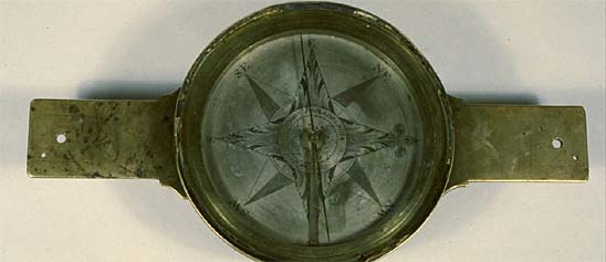
This compass has a wooden bowl gimbal mounted in a wooden box. The inscription on the paper card reads "EDM. M. BLUNT.
Description
This compass has a wooden bowl gimbal mounted in a wooden box. The inscription on the paper card reads "EDM. M. BLUNT. CHART, SELLER, N° 202 WATERSTREET, NEW YORK." The signature is that of Edmund March Blunt (1770-1862), a dealer of nautical supplies who moved from Massachusetts to New York City in 1811 and who retired in the mid-1820s. In the center of the card is an image of a robed figure on land leaning on an anchor and gazing at a ship at sea.
This compass is said to have been on the Niagara on September 10, 1813 when, under the command of Oliver Hazard Perry, American sailors defeated a British squadron in the Battle of Lake Erie.
Location
Currently not on view
date made
ca 1811
maker
Blunt, Edmund March
ID Number
1981.0020.01
accession number
1981.0020
catalog number
1981.0020.01
This unusually small theodolite with an "E. & G. W. Blunt New York" inscription was probably an English instrument that the Blunts imported soon after beginning in business in 1824.
Description
This unusually small theodolite with an "E. & G. W. Blunt New York" inscription was probably an English instrument that the Blunts imported soon after beginning in business in 1824. It may also be one of the surveying instruments that the Rensselaer Polytechnic Institute acquired soon after that school opened in 1824.
The horizontal circle has a beveled edge that is silvered, graduated to 30 minutes, and read by opposite verniers to single minutes. The vertical arc is silvered, graduated to 30 minutes, and read by vernier to single minutes.
Location
Currently not on view
maker
E. & G. W. Blunt
ID Number
2001.0300.01
accession number
2001.0300
catalog number
2001.0300.01
This 56-hour chronometer has a later pattern Earnshaw spring detent escapement, and indications for hours, minutes, seconds, and up and down. It dates from around 1880.
Description
This 56-hour chronometer has a later pattern Earnshaw spring detent escapement, and indications for hours, minutes, seconds, and up and down. It dates from around 1880. The inscriptions read "William Bond & Son, Boston" and "Bond's Break Circuit." The movement, like that of most Bond chronometers, was probably made in England, while the Bond break circuit mechanism was made in the U.S. The Department of Physics at Columbia University donated this instrument to the Smithsonian. The winding key is marked "512" and thus from a different piece.
Location
Currently not on view
date made
ca. 1880
maker
William Bond & Son
ID Number
2001.0162.01
catalog number
2001.0162.01
accession number
2001.0162
Surveyor's compass with an outkeeper on the north arm, and a level vial on each arm. The "B. K. Hagger & Son Makers, Baltimore" refers to a firm that flourished during the years 1824-1838.Currently not on view
Description
Surveyor's compass with an outkeeper on the north arm, and a level vial on each arm. The "B. K. Hagger & Son Makers, Baltimore" refers to a firm that flourished during the years 1824-1838.
Location
Currently not on view
maker
B. K. Hagger & Son
ID Number
1985.0386.02
accession number
1985.0386
catalog number
1985.0386.02
William Dougal (1822–1895) of Washington, D.C. engraved this print of fish species, "Pomotis heros [B&G] and Pomotis fallax [B&G]," after an original sketch by John H. Richard (c.1807–1881) of Philadelphia.
Description (Brief)
William Dougal (1822–1895) of Washington, D.C. engraved this print of fish species, "Pomotis heros [B&G] and Pomotis fallax [B&G]," after an original sketch by John H. Richard (c.1807–1881) of Philadelphia. The engraving was printed as Plate 2 in “Ichthyology of the Boundary” by Charles Girard (1822-1895), published in Volume 2, Part 2 of the Report on the United States and Mexican Boundary Survey. The volume was printed in 1859 by Cornelius Wendell of Washington, D.C.
Description
William Dougal (1822–1895) of Washington, D.C. engraved this print of “Pomotis heros [B&G]and Pomotis fallax [B&G];” now "Lepomis macrochirus" (Bluegill) and "Lepomis megalotis" (Longear sunfish); from an original sketch likely drawn by John H. Richard (c.1807–1881) of Philadelphia. The illustration was published as Plate 2 in the “Fishes” section of the second part of volume II of the Report on the United States and Mexican Boundary Survey, written by Charles Girard (1822–1895). The volume was printed in 1859 by Cornelius Wendell of Washington, D.C.
Location
Currently not on view
date of book publication
1859
original artist
Richard, John H.
graphic artist
Dougal, William H.
author
Girard, Charles
printer
Wendell, Cornelius
author
Emory, William H.
publisher
U.S. Department of the Interior
U.S. Army
ID Number
2009.0115.071
catalog number
2009.0115.071
accession number
2009.0115
William Dougal (1822–1895) of Washington, D.C. is believed to have engraved this print of eel species Anguilla tyrannus (now Anguilla rostrata) after an original illustration by John H. Richard (c.1807-1881) also of Washington, D.C.
Description (Brief)
William Dougal (1822–1895) of Washington, D.C. is believed to have engraved this print of eel species Anguilla tyrannus (now Anguilla rostrata) after an original illustration by John H. Richard (c.1807-1881) also of Washington, D.C. The illustration was printed as Plate 40 in “Ichthology of the Boundary” by Charles Girard (1822–1895), published in Volume 2, Part 2 of the Report on the United States and Mexican Boundary Survey. The volume was printed in 1859 by Cornelius Wendell of Washington, D.C.
Description
William Dougal (1822–1895) of Washington, D.C. engraved this print of “Anguilla tyrannus [Grd]”, now "Anguilla rostrata" or American eel, from an original sketch likely drawn by John H. Richard (c.1807–1881) of Philadelphia. The illustration was printed as Plate 40 in the “Fishes” section of the second part of volume II of the Report on the United States and Mexican Boundary Survey, written by Charles Girard (1822–1895). The volume was printed in 1859 by Cornelius Wendell of Washington, D.C.
Location
Currently not on view
date of book publication
1859
publisher
U.S. Department of the Interior
printer
Wendell, Cornelius
author
Emory, William H.
Girard, Charles
original artist
Richard, John H.
graphic artist
Dougal, William H.
ID Number
2009.0115.106
catalog number
2009.0115.106
accession number
2009.0115
William Dougal (1822–1895) of Washington, D.C. engraved this print of six fish species after original sketches by John H. Richard (c.1807–1881) of Philadelphia.
Description (Brief)
William Dougal (1822–1895) of Washington, D.C. engraved this print of six fish species after original sketches by John H. Richard (c.1807–1881) of Philadelphia. The engraving was printed as Plate 30 in "Ichthyology of the Boundary” by Charles Girard (1822-1895), published in Volume 2, Part 2 of the Report on the United States and Mexican Boundary Survey. The volume was printed in 1859 by Cornelius Wendell of Washington, D.C. The fish species illustrated include: Moniana rutila [Grd], Moniana formosa [Grd], Moniana gibbosa [Grd], Moniana aurata [Grd], Moniana frigida [Grd], and Moniana couchi [Grd].
Description
William Dougal (1822–1895) of Washington, D.C. engraved this print of “Moniana rutila [Grd], Moniana formosa [Grd], Moniana gibbosa [Grd], Moniana aurata [Grd], Moniana frigida [Grd], Moniana couchi [Grd];” now "Cyprinella rutila" (Mexican shiner), "Cyprinella formosa" (Beautiful shiner), "Cyprinella leutrensis" (Red shiner), "Cyprinella proserpina" (Proserpine shiner), "Cyprinella lutrensis" (Red shiner), and "Cyprinella lutrensis" (Red shiner), from an original sketch by John H. Richard (c.1807–1881) of Philadelphia. The illustration was printed as Plate 30 in the “Fishes” section of the second part of volume II of the Report on the United States and Mexican Boundary Survey, written by Charles Girard (1822–1895). The volume was printed in 1859 by Cornelius Wendell of Washington, D.C.
Location
Currently not on view
date of book publication
1859
publisher
U.S. Department of the Interior
printer
Wendell, Cornelius
author
Emory, William H.
original artist
Richard, John H.
graphic artist
Dougal, William H.
author
Girard, Charles
publisher
U.S. Army
ID Number
2009.0115.096
catalog number
2009.0115.096
accession number
2009.0115
William Dougal (1822–1895) of Washington, D.C. engraved this print ofdifferent reptile species after original illustrations by John H. Richard (c.1807-1881) of Philadelphia. The engraving was published as Plate 35 in “Reptiles of the Boundary” by S. F.
Description (Brief)
William Dougal (1822–1895) of Washington, D.C. engraved this print of
different reptile species after original illustrations by John H. Richard (c.1807-1881) of Philadelphia. The engraving was published as Plate 35 in “Reptiles of the Boundary” by S. F. Baird (1823–1887), published in Volume 2, Part 2 of the Report on the United States and Mexican Boundary Survey. The volume was printed in 1859 by Cornelius Wendell of Washington, D.C. The species illustrated describe: “Scaphiopus couchii [Baird], Ambytoma proserpina [B & G], and Ambystoma texana [Baird]”—; now Scaphiopus couchii (common name Couch’s spadefoot or Spadefoot toad), "Ambystoma mavortium" (common name Western tiger salamander) and "Ambystoma texanum" (common name Texas salamander).
Description
William Dougal (1822–1895) of Washington, D.C. engraved this print of “Scaphiopus couchii [Baird], Ambytoma proserpina [B & G], and Ambystoma texana [Baird]”—; now Scaphiopus couchii (Couch’s spadefoot or Spadefoot toad), "Ambystoma mavortium" (Western tiger salamander) and "Ambystoma texanum" (Texas salamander); from an original sketch by John H. Richard (c. 1807–1881) of Philadelphia. The illustration was printed as Plate 35 in the “Reptiles” section of the second part of volume II of the Report on the United States and Mexican Boundary Survey, written by S.F. Baird (1823–1887). The volume was printed in 1859 by Cornelius Wendell of Washington, D.C.
Location
Currently not on view
date of book publication
1859
author
Baird, Spencer Fullerton
original artist
Richard, John H.
graphic artist
Dougal, William H.
printer
Wendell, Cornelius
author
Emory, William H.
publisher
U.S. Department of the Interior
U.S. Army
ID Number
2009.0115.059
catalog number
2009.0115.059
accession number
2009.0115
William Dougal (1822–1895) of Washington, D.C. engraved this print of the fish species Otolithus drummondii [Richards] after original sketches by John H. Richard (c.1807–1881) of Philadelphia.
Description (Brief)
William Dougal (1822–1895) of Washington, D.C. engraved this print of the fish species Otolithus drummondii [Richards] after original sketches by John H. Richard (c.1807–1881) of Philadelphia. The engraving was printed as Plate 6 in “Ichthyology of the Boundary” by Charles Girard (1822-1895), published in Volume 2, Part 2 of the Report on the United States and Mexican Boundary Survey. The volume was printed in 1859 by Cornelius Wendell of Washington, D.C.
Description
William Dougal (1822–1895) of Washington, D.C. engraved this print of “Otolithus drummondii [Richards]”, now "Cynoscion nebulosus" or Spotted seatrout, from an original sketch likely drawn by John H. Richard (c.1807–1881) of Philadelphia. The illustration was printed as Plate 6 in the “Fishes” section of the second part of volume II of the Report on the United States and Mexican Boundary Survey, written by Charles Girard (1822–1895). The volume was printed in 1859 by Cornelius Wendell of Washington, D.C.
Location
Currently not on view
date of book publication
1859
original artist
Richard, John H.
graphic artist
Dougal, William H.
printer
Wendell, Cornelius
author
Emory, William H.
publisher
U.S. Department of the Interior
author
Girard, Charles
publisher
U.S. Army
ID Number
2009.0115.075
catalog number
2009.0115.075
accession number
2009.0115
William Dougal (1822–1895) of Washington, D.C. engraved this print ofdifferent reptile species after original illustrations by John H. Richard (c.1807-1881) of Philadelphia. The illustration was printed as Plate 37 in “Reptiles of the Boundary” by S.F.
Description (Brief)
William Dougal (1822–1895) of Washington, D.C. engraved this print of
different reptile species after original illustrations by John H. Richard (c.1807-1881) of Philadelphia. The illustration was printed as Plate 37 in “Reptiles of the Boundary” by S.F. Baird (1823–1887), published in Volume 2, Part 2 of the Report on the United States and Mexican Boundary Survey. The volume was printed in 1859 by Cornelius Wendell of Washington, D.C. The species illustrated include: “Batrachyla longipes [Baird], Heloecetes clarkia [Baird], Hylarana fusca [Baird], and Acris archeta [sic] [Baird]," now "Eleutherodactylus longipes" (common names Long–footed frog, Long–footed robber frog, or Longfoot robber frog), "Pseudacris clarkia" (common names Clark’s tree frog, Clark’s striped tree frog, or Spotted chorus frog), Hylarana fusca [Baird], and "Acris gryllus" (common name Cricket frog).
Description
William Dougal (1822–1895) of Washington, D.C. engraved this print of “Batrachyla longipes [Baird], Heloecetes clarkia [Baird], Hylarana fusca [Baird], and Acris archeta [sic] [Baird]," now "Eleutherodactylus longipes" (Long–footed frog, Long–footed robber frog, or Longfoot robber frog), "Pseudacris clarkia" (Clark’s tree frog, Clark’s striped tree frog, or Spotted chorus frog), Hylarana fusca [Baird], and "Acris gryllus" (Cricket frog); from an original sketch by John H. Richard (c.1807–1881) of Philadelphia. The illustration was printed as Plate 37 in the “Reptiles” section of the second part of volume II of the Report on the United States and Mexican Boundary Survey, written by S.F. Baird (1823–1887). The volume was printed in 1859 by Cornelius Wendell of Washington, D.C.
Location
Currently not on view
date of book publication
1859
author
Baird, Spencer Fullerton
original artist
Richard, John H.
graphic artist
Dougal, William H.
printer
Wendell, Cornelius
author
Emory, William H.
publisher
U.S. Department of the Interior
U.S. Army
ID Number
2009.0115.061
catalog number
2009.0115.061
accession number
2009.0115
William Dougal (1822–1895) of Washington, D.C. engraved this print of fish species, "Belone scrulator [Grd]," after an original sketch by John H. Richard (c.1807–1881) of Philadelphia.
Description (Brief)
William Dougal (1822–1895) of Washington, D.C. engraved this print of fish species, "Belone scrulator [Grd]," after an original sketch by John H. Richard (c.1807–1881) of Philadelphia. The engraving was printed as Plate 13 in “Ichthyology of the Boundary” by Charles Girard (1822-1895), published in Volume 2, Part 2 of the Report on the United States and Mexican Boundary Survey. The volume was printed in 1859 by Cornelius Wendell of Washington, D.C.
Description
William Dougal (1822–1895) of Washington, D.C. engraved this print of “Belone scrulator [Grd]”, now "Strongylura marina" or Atlantic needlefish, from an original sketch by John H. Richard (c.1807–1881) of Philadelphia. The illustration was printed as Plate 13 in the “Fishes” section of the second part of volume II of the Report on the United States and Mexican Boundary Survey, which was written by Charles Girard (1822–1895). The volume was printed in 1859 by Cornelius Wendell of Washington, D.C.
Location
Currently not on view
date of book publication
1859
publisher
U.S. Department of the Interior
original artist
Richard, John H.
graphic artist
Dougal, William H.
printer
Wendell, Cornelius
author
Girard, Charles
Emory, William H.
publisher
U.S. Army
ID Number
2009.0115.058
catalog number
2009.0115.058
accession number
2009.0115
William Dougal (1822–1895) of Washington, D.C. engraved this print of three fish species after original sketches by John H. Richard (c.1807–1881) of Philadelphia.
Description (Brief)
William Dougal (1822–1895) of Washington, D.C. engraved this print of three fish species after original sketches by John H. Richard (c.1807–1881) of Philadelphia. The engraving was printed as Plate 19 in "Ichthyology of the Boundary” by Charles Girard (1822-1895), published in Volume 2, Part 2 of the Report on the United States and Mexican Boundary Survey. The volume was printed in 1859 by Cornelius Wendell of Washington, D.C. The fish species illustrated include: Ictiobus tumidus [Grd], Ptychostomus albidus [Grd], and Luxilus leptosomus [Grd].
Description
William Dougal (1822–1895) of Washington, D.C. engraved this print of “Ictiobus tumidus [Grd], Ptychostomus albidus [Grd], and Luxilus leptosomus [Grd]”—now "Ictiobus bubalus" (Smallmouth buffalofish), "Moxostoma albidum" (Longlip jumprock), and "Notemigonus crysoleucas" (Golden shiner or Golden shiner minnow); from an original sketch by John H. Richard (c.1807–1881) of Philadelphia. The illustration was printed as Plate 19 in the “Fishes” section of the second part of volume II of the Report on the United States and Mexican Boundary Survey, written by Charles Girard (1822–1895). The volume was printed in 1859 by Cornelius Wendell of Washington, D.C.
Location
Currently not on view
date of book publication
1859
publisher
U.S. Army
author
Girard, Charles
original artist
Richard, John H.
graphic artist
Dougal, William H.
printer
Wendell, Cornelius
author
Emory, William H.
publisher
U.S. Department of the Interior
ID Number
2009.0115.067
catalog number
2009.0115.067
accession number
2009.0115
William Dougal (1822–1895) of Washington, D.C. engraved this print of a fish species after an original sketch by John H. Richard (c.1807–1881) of Philadelphia.
Description (Brief)
William Dougal (1822–1895) of Washington, D.C. engraved this print of a fish species after an original sketch by John H. Richard (c.1807–1881) of Philadelphia. The engraving was printed as Plate 1 in “Ichthyology of the Boundary” by Charles Girard (1822-1895), published in Volume 2, Part 2 of the Report on the United States and Mexican Boundary Survey. The volume was printed in 1859 by Cornelius Wendell of Washington, D.C. Species represented in the engraving include:
Figs. 1- 3 - Caragnus esculentus [Grd], Fig. 4 - Doliodon carolinus [Grd],
Fig. 5 - Chorinemus lanceolatus [Grd], Fig. 6 - Chloroscombrus carribaeus [Grd], (Atlantis bumper), Fig. 7 -- Argyreiosis capillaris [De Kay], and Fig. 8 - Vomer setapinnis [Grd]; now "Oligoplites saurus" (Leatherjacket).
Description
William Dougal (1822–1895) of Washington, D.C. engraved this print of “Caragnus esculentus [Grd], Doliodon carolinus [Grd], Chorinemus lanceolatus [Grd], Chloroscombrus carribeaus [Grd], Argyreiosis capillaris [De Kay], and Vomer setapinnis [Grd]; now "Oligoplites saurus" (Leatherjacket), "Trachinotus carolinus" (Florida pompano), "Oligoplites saurus" (Leatherjacket), "Chloroscombrus carribaeus" (Atlantic bumper), and "Selene setapinnis" (Atlantic moonfish or horsefish); from an original sketch by John H. Richard (c.1807–1881) of Philadelphia. The illustration was printed as Plate 11 in the “Fishes” section of the second part of volume II of the Report on the United States and Mexican Boundary Survey, written by Charles Girard (1822–1895). The volume was printed in 1859 by Cornelius Wendell of Washington, D.C.
Location
Currently not on view
date of book publication
1859
original artist
Richard, John H.
graphic artist
Dougal, William H.
printer
Wendell, Cornelius
author
Emory, William H.
publisher
U.S. Department of the Interior
author
Girard, Charles
publisher
U.S. Army
ID Number
2009.0115.080
catalog number
2009.0115.080
accession number
2009.0115
Dietzgen called this a Forestry or Military Compass with 2-inch needle. The circle is graduated to degrees, and numbered every 10 degrees from 0 to 360. The compass reads counterclockwise. The weight is on the south end of the needle.
Description
Dietzgen called this a Forestry or Military Compass with 2-inch needle. The circle is graduated to degrees, and numbered every 10 degrees from 0 to 360. The compass reads counterclockwise. The weight is on the south end of the needle. In the 1950s, Deitzgen sold this type of compass for $12.50. The cardboard box is stamped: Division of Mechanical and Civil Engineering / U.S. National Museum.
date made
circa 1960
user
Vogel, Robert M.
maker
Eugene Dietzgen Company
ID Number
2007.0214.4
catalog number
2007.0214.4
accession number
2007.0214
This watch belonged to Sir Sandford Fleming, chief engineer of the Canadian Pacific Railway.
Description
This watch belonged to Sir Sandford Fleming, chief engineer of the Canadian Pacific Railway. About 1880, Fleming devised a plan for worldwide time zones and had a complicated watch made to reflect both zoned time and local time.
The maker of Fleming's watch is the London firm of Nicole, Nielsen & Co. Successor to a business founded by Swiss immigrants Adolphe Nicole and Jules Capt in the late 1830s, the firm made high-quality timepieces. Fleming ordered the watch through retailer E. White, also of London.
Fleming's first notions about time reform emerged on a trip to Ireland in 1876, when he missed a train because he misread a timetable. His initial plan concentrated on replacing the two twelve-hour designations of the day, A.M. and P.M., with a twenty-four hour system. Almost immediately, though, he expanded his ideas about time reform to propose a system he called variously "Terrestrial Time," "Cosmopolitan Time," and "Cosmic Time"-a division of the globe into twenty-four zones, each one hour apart and identified by letters of the alphabet.
As the 1880s began there was no binding international agreement about how to keep time for the world. Traditionally, each country used its own capital city or main observatory for measuring time and designating lines of longitude on national maps. After publication of the British Nautical Almanac began in 1767, many nations came to use Greenwich time for navigation and some scientific observations. Local mean time served for all other activities.
Added emphasis on Greenwich had come from North America when the railroads there voluntarily adopted a standard zoned time in 1883. In that system, the zones were based on meridians counted west from Greenwich, England, at zero degree of longitude.
Fleming was not the first or only proponent of world standard time. Quirico Filopanti, an Italian mathematics and engineering professor, for example, published a scheme based on twenty-four zones counted from Rome as prime meridian in 1858.
Organized international support emerged slowly for fixing a common prime meridian. Not until October 1884 did diplomats and technical specialists gather to act on scientific proposals. The International Meridian Conference, held in Washington, DC, recommended that the nations of the world establish a prime meridian at Greenwich, count longitude east and west from the prime meridian up to 180 degrees in each direction, and adopt a universal day beginning at Greenwich at midnight. Although the International Meridian Conference had no authority to enforce its suggestions, the meeting resulted in the gradual worldwide adoption of a time-zone based system with Greenwich as zero degrees.
The military and some civilian science, aviation and navigation efforts still use alphabet identifiers for time zones. The time of day in Zone Z is known as "Zulu Time." The zone is governed by the zero degree of longitude that runs through Greenwich.
Location
Currently not on view
Date made
ca 1880
maker
Nicole, Nielsen & Co.
ID Number
1990.0659.01
catalog number
1990.0659.01
accession number
1990.0659
Range finder with a "STADIMETER U.S. NAVY BUREAU OF ORDNANCE MARK III MOD. 1 NO. 409 / 1918 INSPEC. CHD MADE BY KEUFFEL & ESSER CO. NEW YORK" inscriptions. Unlike the other examples in the collection, this one has a telescopic sight. It was made during World War I.
Description
Range finder with a "STADIMETER U.S. NAVY BUREAU OF ORDNANCE MARK III MOD. 1 NO. 409 / 1918 INSPEC. CHD MADE BY KEUFFEL & ESSER CO. NEW YORK" inscriptions. Unlike the other examples in the collection, this one has a telescopic sight. It was made during World War I. The form was developed in the 1890s by the innovative American naval officer, Bradley Allen Fiske (1854-1942).
Ref: Instructions for the Use and Care of the Fiske Ship-Telegraphs and Stadimeter (Published by Authority of the Bureau of Ordnance, Navy Department, 1896).
Paolo E. Coletta, Admiral Bradley A. Fiske and the American Navy (Lawrence: University of Kansas Press, 1979), pp. 38-40.
Location
Currently not on view
maker
Keuffel & Esser Co.
ID Number
2000.0257.03
accession number
2000.0257
catalog number
2000.0257.03
Anthony Lamb (1703-1784) was born in London, and apprenticed with Henry Carter, a maker of mathematical instruments. In 1724, having been convicted of being an accomplice in a burglary, Lamb was banished to the American colonies. He arrived in Annapolis, Md., in December 1724.
Description
Anthony Lamb (1703-1784) was born in London, and apprenticed with Henry Carter, a maker of mathematical instruments. In 1724, having been convicted of being an accomplice in a burglary, Lamb was banished to the American colonies. He arrived in Annapolis, Md., in December 1724. In December 1730, Lamb advertised in the Pennsylvania Gazette (Benjamin Franklin's newspaper) that he was a "Mathematical Instrument-maker, from London, now living in New-York, near the new Dock, at the Sign of the Compass and the Quadrant." He offered "all Sorts of Instruments for Sea or Land," and the compass on his trade sign was probably a navigational instrument. Lamb soon recognized the importance of the American land, and by 1745 he was trading At the Sign of the Quadrant and Surveying-Compass. In a handbill issued in the early 1750s, Lamb offered "all sorts of Surveying Compasses, with Agate capt Needles."
This brass compass marked "Made & Sold by A. LAMB. New York" was probably made in the 1750s, and is thus one of the earliest instruments of this sort made in America. Following English practice, the face reads clockwise, and the bar is narrow and rather flimsy. The vertical sights fold down when not in use. David Rittenhouse would begin making surveyor's compasses with counterclockwise faces and sturdy baseplates in the 1760s.
Ref: Silvio A. Bedini, At the Sign of the Compass and Quadrant. the Life and Times of Anthony Lamb (Philadelphia: American Philosophical Society, 1984).
Location
Currently not on view
date made
1750s
also made surveyor's compasses
Rittenhouse, David
maker
Lamb, Anthony
ID Number
PH.325900
catalog number
325900
accession number
251930
After Alabama became a state in 1819 and after the Indian Removal Act of 1830, white settlers and their African slaves arrived in the area in great numbers. This map was created under the auspices of the General Land Office, a federal agency that was formed in 1812.
Description
After Alabama became a state in 1819 and after the Indian Removal Act of 1830, white settlers and their African slaves arrived in the area in great numbers. This map was created under the auspices of the General Land Office, a federal agency that was formed in 1812. The agency took over functions begun under the Federal Land Ordinance of 1785.
This map shows Alabama divided into square townships 6 miles on each side (townships at the edges of the state tend to be smaller and irregular in shape). Some townships are designated A, B, C, D, or X. The scale seems to be 18 miles to the inch. The identified towns are Cahaba, Florence, Huntsville, Mardisville, Mobile, Montgomery, Sparta, St. Stephens, Tuscaloosa, and Wetumka. The Cherokee Cession is shown, as are the Choctaw Cession of 1830, the Chickasaw Cession of 1833, and the Creek Cession of 1832. One meridian runs through St. Stephens, a settlement along the Tombigbee River (here spelled Tombeckee) that served as the original capital of the Alabama Territory. Another meridian runs through Huntsville, the first incorporated town in the region. An east-west line at 31° north latitude divides Alabama from West Florida. Another east-west line divides the Northern and Southern surveyor’s districts.
The text at bottom reads “Exhibiting the situation of the Public Surveys, shewing what records of the same are on file in the General Land Office and the Surveyor General’s Office, the Townships, the field notes of which are yet to be transcribed for the General Land Office and recorded in this Office, also, what Townships the original field notes of which are not on file in either Office, having been destroyed by fire in December 1827, and which have to be retraced for the purpose of obtaining the Original Land Marks to be preserved on record in the General Land Office and This Office. Surveyor’s Office, Florence Alabama Jas H. Weakley Surveyor General of the Public Lands in Alabama.”
Ref: Jas. H. Weakley to James Whitcomb, Commissioner of the General Land Office, Nov. 16, 1840, in Public Documents Printed by Order of the Senate of the United States (Washington, D.C., 1841), vol. 3, pp. 134-135.
Location
Currently not on view
date made
1840
ID Number
PH.317489
catalog number
317489
accession number
230397
This instrument marked "W. & L. E. Gurley, Troy, N.Y." was made between 1868 when the Gurleys introduced a railroad compass with one vernier scale on the limb, and the middle of 1876 when the firm's engraving machine was up and running. New, it cost $70.
Description
This instrument marked "W. & L. E. Gurley, Troy, N.Y." was made between 1868 when the Gurleys introduced a railroad compass with one vernier scale on the limb, and the middle of 1876 when the firm's engraving machine was up and running. New, it cost $70. It belonged to Bowdoin College. The upper plate carries the sights, two level vials, and the compass. The lower plate, wider than the upper, carries the circle which is graduated to 30 minutes, and read by vernier to single minutes. A tangent screw on the south arm moves the two plates relative to one another. There is a variation arc on the compass face that extends 30 degrees either way; the folded vernier is moved by a rack and pinion located on the north arm, and reads to 2 minutes. It has a blackened or bronzed finish, and a silver–plated face.
Ref: W.&L.E. Gurley, A Manual of the Principal Instruments Used in American Engineering and Surveying (Troy, N. Y., 1868), pp. 52–56.
W. Skerritt, "W.&L.E. Gurley's Engraving Machine," Rittenhouse 11 (1997): 97–100.
Location
Currently not on view
date made
1868-1876
maker
W. & L. E. Gurley
ID Number
PH.329729
catalog number
329729
accession number
278336
Mercury-in-glass thermometer with a milk white tube and metal bulb guard.
Description
Mercury-in-glass thermometer with a milk white tube and metal bulb guard. The supporting metal plate is marked, at top, “TAYLOR BRO’S / ROCHESTER, N.Y.” and graduated from 8 to +120 degrees Fahrenheit, with indications for “FREEZ/ING,” “TEMPE/RATE,” SUMR/HEAT,” and “BLOOD/HEAT.” This is mounted, in turn, on a wood board. It came to the Smithsonian in 1923.
Location
Currently not on view
date made
1872-1890
maker
Taylor Brothers
ID Number
PH.308155
catalog number
308155
accession number
70532
This is timing equipment from NASA's Goldstone Deep Space Communications Complex in the Mojave Desert near Barstow, Calif. It was installed at Goldstone about 1984.
Description
This is timing equipment from NASA's Goldstone Deep Space Communications Complex in the Mojave Desert near Barstow, Calif. It was installed at Goldstone about 1984. Based on specifications from NASA's Goddard Space Flight Center, the assembly was designed and made by TRAK Microwave of Tampa, Florida, and used at Goldstone to provide time codes for the ground station and space navigation until 2006. While in service, the assembly timed an impressive list of missions, including the two Voyagers launched in 1977 and the highly publicized Mars missions in 1996, 2001, 2003 and 2005. The equipment could track about thirty missions simultaneously and served about one hundred users.
The assembly contains three clocks—Clocks A, B and C (2008.0145.01, .02, and .03)—that work together as the master clock. Also known as a triple redundant clock, the three together "vote" on a single time of day, with agreement between two of the three determining the correct time. The master clock receives a reference frequency from a suite of atomic frequency standards (one primary and three backups). The master clock converts that frequency into time codes. Reference frequency signals and time codes are in turn distributed by the time insertion distribution system (2008.0145.04) to user locations in NASA's Deep Space Network for tracking spacecraft and radioastronomy experiments.
Time and frequency are essential to the Deep Space Network, a group of three communications facilities placed approximately 120 degrees apart around the world at Goldstone, near Madrid, Spain and near Canberra, Australia. The network synchronizes the three stations plus the Jet Propulsion Laboratory in Pasadena, CA, to an accuracy of microseconds through comparisons with each other and with time from the Global Positioning System.
Location
Currently on loan
date made
ca 1984
ID Number
2008.0145.01
accession number
2008.0145
catalog number
2008.0145.01
The narrow bar, dovetails holding the vertical sights in place, and face that reads clockwise, suggest that this compass dates from the middle years of the 18th century, when its owner, a Quaker preacher named Benjamin Ferris, settled at Quaker Hill in Dutchess County, N.
Description
The narrow bar, dovetails holding the vertical sights in place, and face that reads clockwise, suggest that this compass dates from the middle years of the 18th century, when its owner, a Quaker preacher named Benjamin Ferris, settled at Quaker Hill in Dutchess County, N. Y.
Ref: Conrad S. Ham, "A Family History of a Group of Surveying Instruments 1750 to the Present Year 1954," Annual Report of Proceedings of the Connecticut Society of Civil Engineers 70 (1954): 134-138.
Location
Currently not on view
ID Number
1983.0548.01
accession number
1983.0548
catalog number
1983.0548.01
Uriah Atherton Boyden was a consulting engineer in Boston whose water wheels and turbines brought riches and fame. He also introduced a hook gauge for determining the depth of water flowing over a weir or dam. James B.
Description
Uriah Atherton Boyden was a consulting engineer in Boston whose water wheels and turbines brought riches and fame. He also introduced a hook gauge for determining the depth of water flowing over a weir or dam. James B. Francis, the engineer who designed most of the water power systems used at Lowell, Mass., in the mid-nineteenth century, described this hook gauge as “an instrument of inestimable value in hydraulic experiments.” Francis went on to say that “All other known methods of measuring the heights of the surface of still water, are seriously incommoded by the effects of capillary attraction; this instrument, on the contrary, owes its extraordinary precision to that phenomenon.”
Several American firms offered instruments of this sort. The Proprietors of the Locks and Canals at Lowell donated this unsigned example to the Smithsonian in 1956. It may have been used by Francis.
Ref: James B. Francis, Lowell Hydraulic Experiments (New York, 1855), pp. 18-19.
Keuffel & Esser, Catalogue (New York, 1913): 461.
Location
Currently not on view
date made
mid 19th century
ID Number
PH.314775.01
accession number
211155
catalog number
314775.01
Octant with an ebony frame, reinforced brass index arm, and telescopic sight. The ivory scale is graduated every 20 minutes from -2° to +111° and read by vernier and tangent screw to single minutes of arc. The "E. & G. W.
Description
Octant with an ebony frame, reinforced brass index arm, and telescopic sight. The ivory scale is graduated every 20 minutes from -2° to +111° and read by vernier and tangent screw to single minutes of arc. The "E. & G. W. BLUNT, New York" inscription may indicate that it was made after 1857 when the Blunts began offering nautical instruments "of American manufacture," and before 1866 when the firm became Blunt & Nichols.
The inscription on the brass nameplate reads: "George Davidson. Philadelphia, Pa." George Davidson (1825-1911) was a surveyor, geodesist and astronomer affiliated with the U.S. Coast Survey.
Ref: Deborah J. Warner, "American Octants and Sextants: The Early Years," Rittenhouse 3 (1989): 86-112, on 91-92.
"George Davidson," American National Biography, vol. 6, pp. 143-144.
Location
Currently not on view
date made
mid 19th century
maker
E. & G. W. Blunt
ID Number
PH.314492
catalog number
314492
accession number
204107

Our collection database is a work in progress. We may update this record based on further research and review. Learn more about our approach to sharing our collection online.

If you would like to know how you can use content on this page, see the Smithsonian's Terms of Use. If you need to request an image for publication or other use, please visit Rights and Reproductions.