Photography

The millions of photographs in the Museum's collections compose a vast mosaic of the nation's history. Photographs accompany most artifact collections. Thousands of images document engineering projects, for example, and more record the steel, petroleum, and railroad industries.

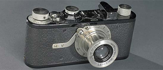
Some 150,000 images capture the history, art, and science of photography. Nineteenth-century photography, from its initial development by W. H. F. Talbot and Louis Daguerre, is especially well represented and includes cased images, paper photographs, and apparatus. Glass stereographs and news-service negatives by the Underwood & Underwood firm document life in America between the 1890s and the 1930s. The history of amateur photography and photojournalism are preserved here, along with the work of 20th-century masters such as Richard Avedon and Edward Weston. Thousands of cameras and other equipment represent the technical and business side of the field.

Text and photograph from Gardner's Photographic Sketchbook of the War, Vol. II.
Description
Text and photograph from Gardner's Photographic Sketchbook of the War, Vol. II. Negative by James Gardner, text and positive by Alexander Gardner.
This sketch represents one of the pontoon bridges across the James River, at Powhattan Point, near Harrison's Landing, and not far from Charles City Court-House; and which was used by Gen. Grant's army, in his march from Coal Harbor to City Point. The bridge was laid down on the fourteenth of June, 1864, and the troops commenced crossing the next day. Gen. Warren's Corps moved from its position, one mile in rear of Coal Harbor, and marched across the Richmond and York River Railroad, taking the Long Bridge road over the Chickahominy and down to the James, followed by Hancock, Wright and Burnside; the Eighteenth Corps having already occupied Bermuda Hundreds, on the north side of the James, several miles above the pontoons. The enemy made no attempt to interrupt the movement, confining himself to the defences of Richmond. The passage of the James River was effected without the loss of a gun or wagon, Wilson's Cavalry covering the rear from attack, and enabling the army to cross without any undue haste. After the infantry had passed over, the immense wagon trains crossed, followed by the cattle herds, and finally by the Cavalry. The scene at this point during the passage of the river by the army was most spirited. The stream was crowded with gunboats, transports and sailing vessels, as far as the eye could reach, while on both sides of the river a long cloud of dust marked the line of march across the level country. Simultaneously with this movement of our troops, the rebels left their defences [sic] north of Richmond, and marched through that city towards Petersburg, in front of which the first engagement took place on the fifteenth, resulting in the capture of the enemy's entrenchments and the occupation of the city by our Cavalry. Unfortunately the advantage thus gained was not held, the cavalry falling back upon our Infantry, which failed to get up in time to prevent the rebels from reoccupying the city.
During the passage of the army across the James, the mails and passengers were brought on steamers from Washington to these bridges, and transferred by means of small boats, to steamers above the pontoons, thus enabling them to reach City Point and Bermuda Hundreds without much delay. No better summary of these few days' events can be given, than in the despatch of Gen. Grant to the President, on the seventeenth. He says, "The Ninth Corps crossed this morning, carried two more redoubts, forming a part of the defences [sic] of Petersburg, capturing four hundred and fifty prisoners and four guns. Our successes are being followed up. Our forces drew out from within fifty yards of the enemy's intrenchments, at Coal Harbor, made a flank movement, of about fifty-five miles march, crossing the Chickahominy and James Rivers – the latter two thousand feet wide and eighty-four feet deep at the point of crossing – and surprised the enemy's rear at Petersburg. This was done without the loss of a wagon or piece of artillery, and only about one hundred and fifty stragglers were picked up by the enemy. In covering this move, Warren's Corps and Wilson's Cavalry had frequent skirmishing with the enemy, each losing from fifty to sixty killed and wounded, but inflicting an equal if not greater loss upon the enemy."
Location
Currently not on view
date made
1864-06
maker
Gardner, Alexander
ID Number
1986.0711.0283.19
accession number
1986.0711
catalog number
1986.0711.0283.19
Text and photograph from Gardner's Photographic Sketchbook of the War, Vol. II. Negative by Barnard & Gibson, text and positive by Alexander Gardner.These were found in the works at Centreville, after the position at Manassas Junction was evacuated by the rebels.
Description
Text and photograph from Gardner's Photographic Sketchbook of the War, Vol. II. Negative by Barnard & Gibson, text and positive by Alexander Gardner.
These were found in the works at Centreville, after the position at Manassas Junction was evacuated by the rebels. It was claimed, and is believed by many, that the rebel lines at Centreville were never defended by any others; yet the rebels had in position there at least seven heavy siege guns and numerous field batteries. Capt. Porter, then commanding the First Massachusetts Light Battery, found in one park the tracks of ten batteries. As for the "Quakers," it was not at all an uncommon thing to place them upon deserted positions. Our soldiers, at the evacuation of Harrison's Landing, left the works so well supplied with "Quaker" guns, and bogus figures on guard duty, that it was several days before the rebels ventured to approach them. These Centreville works, in consequence of their natural advantages, were almost impregnable to attack. The rifle-pits covering the crest of the hill were strengthened at intervals with embrasured forts, the whole commanding the natural glacis, gently descending for half a mile to the little stream called Rocky Run, and the opposite slope, to its crest half a mile distant. The huts in the distance were a portion of the rebel cantonments, numbering in all about fifteen hundred log cabins, calculated to contain from eight to twenty men each. The fort in the foreground has a revetement or lining of rude hurdle work, to keep the earth from crumbling down, a very necessary precaution with the Virginia soil. The board platforms show where guns have formerly been in position, commanding the approaches from Fairfax Court-House. It was to these heights that Gen. Meade returned with the Army of the Potomac, after it had been reduced by the transfer of the Eleventh and Twelfth Corps to the West. Lee followed, meeting with a repulse from Gen. Warren, at Bristow Station, and declining the proffered battle at Centreville, fell back to the Rapidan, destroying the railroad as he retreated.
Location
Currently not on view
date made
1862-03
maker
Gardner, Alexander
ID Number
1986.0711.0334.06
accession number
1986.0711
catalog number
1986.0711.0334.06
Text and photograph from Gardner's Photographic Sketchbook of the War, Vol. II.
Description
Text and photograph from Gardner's Photographic Sketchbook of the War, Vol. II. Negative by Alexander Gardner, text and positive by Alexander Gardner.
When Jefferson Davis directed the evacuation of Richmond, he left instructions with Breckinridge and Ewell to burn the Confederate supplies and munitions of war. Davis left on Sunday night, and on the following morning, after they had crossed the river, this bridge was fired. The structure was built of wood, and rested on sixteen large stone piers. It had two passage-ways, one along the top for the cars, and one beneath the railroad track, for carriages. This view was taken from the Richmond side of the river, where are the ruins of a large paper mill.
In the back ground are seen the heights of Manchester, on which the rebels erected earthworks to defend Richmond when General Butler was making demonstrations from Bermuda Hundreds. The river is shallow at this point, and obstructed by huge boulders, between which are holes where the water is dune deep, rendering the stream unfordable. Belle Isle, where so many Union prisoners were starved and frozen, is about three fourths of a mile above this bridge.
A new structure has been built on the piers since this photograph was made, and the trains now cross regularly. Many of the ruins along the river side have been removed. Handsome buildings are in progress of erection, and the cities of Richmond and Manchester are resuming their bustle of trade and improvement.
Location
Currently not on view
maker
Gardner, Alexander
ID Number
1986.0711.0283.38
accession number
1986.0711
catalog number
1986.0711.0283.38
Text and photograph from Gardner's Photographic Sketchbook of the War, Vol. II. Negative by Timothy H. O'Sullivan, text and positive by Alexander Gardner.This bridge is on the road known as the Telegraph road to Richmond. On the 23d of May Gen.
Description
Text and photograph from Gardner's Photographic Sketchbook of the War, Vol. II. Negative by Timothy H. O'Sullivan, text and positive by Alexander Gardner.
This bridge is on the road known as the Telegraph road to Richmond. On the 23d of May Gen. Hancock found it defended by earthworks, manned, and offering a spirited resistance. These were speedily carried by a brilliant assault of the old "Berry Brigade," and the bridge taken before damage had been done it by the defenders. The 93d New York, in the heat of the charge, carried their colors to the centre of the structure, the enemy still holding the opposite bank. The bridge and its approaches remained exposed to the fire of a battery of the enemy, so posted that the Union artillery could not silence it as long as we held possession. Everything crossing it had to run the gauntlet of a wicked fire, rapidly delivered, and at good range. Pouring over at the double-quick, those commands that were obliged to cross, offered a capital mark to the rebel gunners. In this way several large regiments of New York heavy artillery went over, not without serious casualties, the shells bursting about their heads with deafening explosions. Captain Bleeper's battery, the 10th Massachusetts, crossed it about this time, the rebels redoubling their efforts in hope of blowing up the ammunition, but the captain only passed over one piece at a time, thus materially diminishing the target; and as the rule is to go no faster than a walk, (unless at the risk of severe pains and penalties at the hands of the local authorities), the aforesaid captain passed over with each piece in turn, enforcing the observance of the law, and proving the discipline of his battery. The ridge in the distance was the position held by the Second Corps, till it was determined not to advance any further in that direction.
It is a curious fact that this bridge received hardly any damage from the continual fire of the rebel battery; nor was the loss among the troops exposed to it anything like what might have been expected, owing to the fire of the Second Corps artillery, which must have considerably confused its aim.
Location
Currently not on view
date made
1864-05
maker
Gardner, Alexander
ID Number
1986.0711.0283.16
accession number
1986.0711
catalog number
1986.0711.0283.16
Text and photograph from Gardner's Photographic Sketchbook of the War, Vol. II. Negative by David Knox, text and positive by Alexander Gardner.This photograph represents one of the forges used by the army at Petersburg, and was taken during the intense heat of a summer day.
Description
Text and photograph from Gardner's Photographic Sketchbook of the War, Vol. II. Negative by David Knox, text and positive by Alexander Gardner.
This photograph represents one of the forges used by the army at Petersburg, and was taken during the intense heat of a summer day. The trees in the distance are dimly seen through the tremulous air, and the pine twigs droop from the eaves of the but as if a fire had scorched them. The hoofs of the horse are buried in burning dust, and the boots of the men are loaded with powdered earth. By the tall pine in the back-ground, a little tent seems to be vainly seeking the shadow, while over all glares a hot sky, without a cloud to relieve the weary eyes. The parched ground and arid appearance of the landscape was characteristic of the country about Petersburg, where the constant movements of troops crushed out vegetation. Forests, houses, and fences were swept away, and the fields were transformed into vast commons, where the winds raised clouds of sand, and covered everything with the sacred soil. On these glaring deserts, with no covering but the shelter tent and withered brush, the army toiled and fought through many months, filling the valleys with graves, and sapping the vigor of men in the prime of life. Many are the dead that might now be living but for the poison of those torrid days, and all through the land are feeble veterans, who look back upon that campaign as does the pilgrim on his journeyings across the great Sahara.
Location
Currently not on view
date made
1864-08
maker
Gardner, Alexander
ID Number
1986.0711.0283.27
accession number
1986.0711
catalog number
1986.0711.0283.27
Text and photograph from Gardner's Photographic Sketchbook of the War, Vol. II. Negative by Timothy H.
Description
Text and photograph from Gardner's Photographic Sketchbook of the War, Vol. II. Negative by Timothy H. O'Sullivan, text and positive by Alexander Gardner.
"Old Blanford Church," of which a view is here presented, is a great object of interest to all visitors; the cemetery surrounding it having monuments erected one hundred and fifty years ago. The walls of the main body of the building are of English brick, imported from the mother country. The services of the Episcopal Church were first performed in 1735, and continued to be read until 1825, nearly a century. Since that time, owing to the movement of the inhabitants of Blandford to the present site of Petersburg, the church has not been used, although the cemetery, now much enlarged, still continues to be the general depository of the dead. The ivy-covered walls now stand as a historic monument of what was formerly the aristocratic portion of the city. In the cemetery the stranger is not only shown the almost obliterated slab beneath which rests the remains of General Phillips, who died in May, 1781, during the war of independence, but also the monument. erected to the memory of the brave volunteers from the "Cockade City," who left houses and friends in the war of 1812. The greater space, however, has been allotted during the last four years to the graves of "Our Soldiers," these words being cut on a simple wooden cross, to mark the resting place of the Confederate dead.
A somewhat eccentric sexton, whose father before him performed the same duties, is generally on the spot to enlighten visitors in regard to the history of the church, and is apparently much pleased to do so from the manner in which he enters upon his oft-repeated narrative. During the siege the edifice and its surroundings suffered but little damage from shot or shell, although the position was in front of the point of attack at the time of the explosion of the mine on the 30th July, 1864.
Location
Currently not on view
date made
1865-04
maker
Gardner, Alexander
ID Number
1986.0711.0283.35
accession number
1986.0711
catalog number
1986.0711.0283.35
Text and photograph from Gardner's Photographic Sketchbook of the War, Vol. II. Negative by William R.
Description
Text and photograph from Gardner's Photographic Sketchbook of the War, Vol. II. Negative by William R. Pywell, text and positive by Alexander Gardner.
This sketch represents a portion of the field of the battle of Bull Run, fought on the 21st of July, 1861, by the forces under Gen. McDowell and Gen. Beauregard. In a general order, issued on the 20th, Gen. McDowell said: "The enemy has planted a battery on the Warrenton turnpike to defend the passage of Bull Run; has seized the stone bridge, and made a heavy abatis on the right bank, to oppose our advance in that direction. The ford above the bridge is also guarded, whether with artillery or not, is not positively known, but every indication favors the belief that he proposes to defend the passage of the stream. It is intended to turn the position, force the enemy from the road, that it may be re-opened, and, if possible, destroy the railroad leading from Manasses to the Valley of Virginia, where the enemy has a large force." General McDowell commenced operations with the divisions of Tyler, Hunter, Heintzelman, and Miles-33,000 men; 18,000 of whom were engaged. The strength of the enemy was about the same, and was all engaged. The plan of the attack was for Tyler's division to threaten the passage of the bridge, Miles to make a demonstration at Blackburn's Ford, two miles below, and the divisions of Hunter and Heintzleman to move up the stream ten miles, and by a flank movement surprise and overwhelm the enemy while occupied with the two other divisions.
The country at that time was densely wooded, and the entire portion shown in the sketch occupied by the Confederates. It was expected that Hunter and Heintzelman would strike the left of the enemy at daylight on the 21st, but owing to unforeseen obstacles, failed to reach the designated point until after ten o'clock. This delay revealed the movement to Beauregard, who immediately disposed his forces to meet it by extending them obliquely across the turnpike, facing the bridge, at a distance of about two miles. Hunter, Heintzelman, and Tyler, who had crossed the bridge, attacked the enemy, and the engagement became general; our forces, after a severe struggle, driving him in great confusion from the field, and occupying the turnpike. The fighting had nearly ceased, and Gen. McDowell was expressing his thanks to some of his officers for their services, when Johnston's reinforcements from Winchester suddenly appeared in rear of our right, and threw our lines into utter confusion. A feeble attempt was made to repulse the attack, but the regiments rapidly broke to pieces, and forming a mass of terror-stricken fugitives, rushed from the field down across the bridge, which soon became obstructed by wagons, and to prevent pursuit by the enemy was destroyed. A portion of this ground was fought over in the battles of Gen. Pope in 1862, and hundreds of acres still bear evidences of those fearful scenes.
Location
Currently not on view
date made
1862-03
maker
Gardner, Alexander
ID Number
1986.0711.0334.07
accession number
1986.0711
catalog number
1986.0711.0334.07
Text and photograph from Gardner's Photographic Sketchbook of the War, Vol. II. Negative by John Reekie, text and positive by Alexander Gardner.This rude obstruction illustrates the anxiety which possesses the soldier to provide a protection from the fire of his enemy.
Description
Text and photograph from Gardner's Photographic Sketchbook of the War, Vol. II. Negative by John Reekie, text and positive by Alexander Gardner.
This rude obstruction illustrates the anxiety which possesses the soldier to provide a protection from the fire of his enemy. With such material as a few hastily collected rails, or fallen timber, it was often possible to hold a point, totally untenable without such defence. At Cold Harbor the rebels had three or four lines of battle behind as many lines of rifle pits. Along much of the front the two lines were so close that the intervening space resembled a road, fearfully encumbered with dead and wounded. So intense was the animosity exhibited here, by the Confederate army, that if one of our wounded men was observed to move, for the purpose of crawling back to his comrades, it was certain to draw upon him a severe fire. At other points, the space appeared entirely deserted between the hostile rifle pits, neither party daring to rise and look over. There were only the banners, scarred and torn, and the hum of many voices, to give evidence of what might be expected if either party should attack. Occasionally the Union soldiers would arrange their muskets so as to command the top of the opposing earthworks, and then setting up a great shout, would impress the enemy with the idea that an attack was about to be made. The Confederates would spring up to repel it, and before they discovered the ruse a well directed volley would thin their ranks. It was almost impossible to guard against this manoeuvre, as the lines were so near each other that a charge not promptly met would prove successful in the capture of the works.
This extraordinary proximity kept all upon the alert, more particularly after dark, when the nervousness of the troops could not be controlled. The quiet movements of small parties, outside the line, searching for friends among the wounded, was sufficient to raise an alarm. Sometimes the night alarm was altogether a matter of imagination. A few scattered shots was generally the prelude to a heavy and continuous fire of musketry and artillery along the front. It is impossible to describe the sensations experienced on hearing, for the first time, one of these midnight engagements. But even these became common-place in time, and scarcely disturbed the slumber of those in the camps at the rear.
Location
Currently not on view
date made
1865-04
maker
Gardner, Alexander
ID Number
1986.0711.0283.46
accession number
1986.0711
catalog number
1986.0711.0283.46
Text and photograph from Gardner's Photographic Sketchbook of the War, Vol. II. Negative by Timothy H.
Description
Text and photograph from Gardner's Photographic Sketchbook of the War, Vol. II. Negative by Timothy H. O'Sullivan, text and positive by Alexander Gardner.
The scenery hereabouts is of a highly romantic character, the ground being very much broken, and the water, "now seen in sunshine, now lost in shade, having to find its way, as best it can, over an exceedingly rough bed, and through various intricate channels formed by the rocks and several small, but densely wooded, islands, until it reaches the narrow granite gorge, or strait, spanned by the bridge. Through the latter it rushes with accelerated force to Bolling's Dam, and thence pursues its course more quietly to City Point, there to be swallowed up by the mightier James.
On the right hand side of the view here taken is introduced a portion of one of the "Merchant Manufacturing Company's Cotton Mills," established in the early part of the year 1832, and employing, we are told, one hundred and fifty to two hundred operatives. In the middle ground are several other buildings, some being used for the grinding of corn and such purposes, and others as saw-mills, the water power being here very extensive; while in the background of the picture is to be seen the high road abruptly ascending from Petersburg, by way of Campbell's Bridge towards Enricks [sic], and into the county of Chesterfield generally.
Location
Currently not on view
date made
1865-05
maker
Gardner, Alexander
ID Number
1986.0711.0283.32
accession number
1986.0711
catalog number
1986.0711.0283.32
Text and photograph from Gardner's Photographic Sketchbook of the War, Vol. II. Negative by Timothy H.
Description
Text and photograph from Gardner's Photographic Sketchbook of the War, Vol. II. Negative by Timothy H. O'Sullivan, text and positive by Alexander Gardner.
In such rude manner did the lusty artificers of the corps carry on their needful trades, doing much good work under the scorching rays of the southern sun. At one time the majority of these hardy workmen were detailed from the ranks, with extra pay and allowances, but when every soldier was needed behind his musket, skilled men were hired for such duty, and some of the soldiers ordered back to their regiments. On the right of the view is the stocks, a neat contrivance, to facilitate the shoeing of mules, an operation which those self-willed animals had a decided objection to undergo. Time being precious, the farriers could not be expected to waste much in the exercise of their persuasive abilities. The refractory mule was led into the stocks, often by the seductive display of a peck of oats, suddenly to find himself suspended in air upon a huge belly-band. Four stout fellows seizing his feet, fastened them securely with thongs in the required position, and while impotent rage convulsed his frame, rapidly nailed on the shoes, finally releasing the hybrid in a state of wretched uncertainty as to the intents and purposes of his masters.
The tent fly, with its partial walls of loose bricks, covers the forge. Around it are the wheel and harness-makers, evidently resting, with pleasing expectations of forming a prominent feature of the photograph, while the contrabands have assumed positions of determined fixedness, worthy of the occasion.
Location
Currently not on view
date made
1864-02
maker
Gardner, Alexander
ID Number
1986.0711.0283.20
accession number
1986.0711
catalog number
1986.0711.0283.20
Text and photograph from Gardner's Photographic Sketchbook of the War, Vol. II. Negative by Timothy H.
Description
Text and photograph from Gardner's Photographic Sketchbook of the War, Vol. II. Negative by Timothy H. O'Sullivan, text and positive by Alexander Gardner.
About nine o'clock on the morning of the 1st of July, 1863, the Federal cavalry, under General Buford, met the Confederates two miles beyond Gettysburg, on the road to Chambersburg. The rebel infantry was preceded by a small body of their cavalry, which dispersed the militia wherever met with, and which, charging into our cavalry, was captured, not a man escaping. The Confederates immediately threw a division of infantry into line, and advanced upon our cavalry, which dismounted, and by slowly falling back from one stone wall to another, impeded the progress of the enemy very materially. The cavalry had just taken up the last available line of defense [sic] beyond Gettysburg, when, at eleven o'clock, General Reynolds arrived with the 1st corps on a double-quick. The enemy then halted for a short time, re-formed their lines, and prepared to charge, which was met by a severe fire from the advance of our infantry, which went into line as rapidly as the regiments could be brought up General Reynolds, appreciating the importance of holding the Seminary Ridge, rode out into the field, and directed the posting of the troops, and while engaged in this work, received a shot in the neck, falling lifeless to the earth. His remains were brought off the field under a withering fire, which lasted until night, our troops, overwhelmed by numbers, slowly falling back, and finally taking a position on Cemetery Ridge, which was next day occupied by the rest of our army, and became the battle-ground of the succeeding days.
The dead shown in the photograph were our own men. The picture represents only a single spot on the long line of killed, which after the fight extended across the fields. Some of the dead presented an aspect which showed that they had suffered severely just previous to dissolution, but these were few in number compared with those who wore a calm and resigned expression, as though they had passed away in the act of prayer. Others had a smile on their faces, and looked as if they were in the act of speaking. Some lay stretched on their backs, as if friendly hands had prepared them for burial. Some were still resting on one knee, their hands grasping their muskets. In some instances the cartridge remained between the teeth, or the musket was held in one hand, and the other was uplifted as though to ward a blow, or appealing to heaven. The faces of all were pale, as though cut in marble, and as the wind swept across the battle-field it waved the hair, and gave the bodies such an appearance of life that a spectator could hardly help thinking they were about to rise to continue the fight.
Location
Currently not on view
date made
1863-07
maker
Gardner, Alexander
ID Number
1986.0711.0334.37
accession number
1986.0711
catalog number
1986.0711.0334.37
Text and photograph from Gardner's Photographic Sketchbook of the War, Vol. II. Negative by Timothy H.
Description
Text and photograph from Gardner's Photographic Sketchbook of the War, Vol. II. Negative by Timothy H. O'Sullivan, text and positive by Alexander Gardner.
This wagon park represents the transportation of all that portion of the Quartermaster's Department, which included the various field repair shops, carpenters, saddlers, harness-makers, blacksmiths, wheelwrights, wagon builders, and the like, belonging to the Army of the Potomac. When in full operation it was a very extensive establishment, and one of much importance to the army. Thousands of mules and horses were here shod every month, and almost an equal number of disabled wagons, ambulances, &c., repaired, the rough usage to which the trains were subjected breaking down even the strongest-built army wagons. In addition to the repairs done here, there were made tables, seats, and desks, for office furniture, required by the various departments in camp. Indeed, it would be difficult to say what the Quartermaster might not have to construct or mend at a moment's notice. Sometimes Col. Pierce, the officer in charge, would find a whole division of cavalry upon his hands, in the most unexpected manner; just in from a raid or a fight, their own proper depot out of reach, and all in want of shoes to their horses and repairs to their equipments. Then there were lively times at the repair shops; harness-sewers working to distraction, and blacksmiths punishing their anvils day and night, while the cry was "still they come." At other times, while the summer campaigns were in progress, there would be little to do but keep the mules harnessed for a start, and lounge upon the ground, or around the sutler's wagon.
This train numbered about two hundred and forty wagons – no trifling command to move with precision and safety over a country almost destitute of paved roads; but when compared with the entire transportation of the army, it was a small matter. For the carriage of ordnance, commissary and quartermaster stores, the baggage of the troops, and for transporting the sick and wounded, nearly six thousand wagons and ambulances had to be put in motion, requiring at least sixty miles of road to string out upon. Moving upon dirt roads, generally cut up by the wheels of over three hundred guns, the same number of caissons, the accompanying forges and battery wagons, and a pontoon train or two – the labor required by the draught animals was excessive. As for the swearing done by the teamsters, no words can describe its amount, nor can any memory do justice to its variety and originality. But for these immense trains, and their cumbrous movements, many a battle would have remained unfought, an engagement sometimes being absolutely necessary for their preservation. One of these was the battle of Bristow Station, where the rebel army made a flank attack upon the Second Corps, hoping, by a vigorous assault, to drive our men, and cripple the army by destroying its train, moving under cover of the column of infantry.
When collected in one encampment, the sight of the vast parks of wagons was very imposing. On one occasion, two days before the battle of Bristow, almost the entire transportation of the army was accumulated in the vicinity of Bealton, covering the fields in all directions as far as the eye could reach with white covers, all stamped, with the badge of their respective corps, division and brigade.
Location
Currently not on view
date made
1863-05
maker
Gardner, Alexander
ID Number
1986.0711.0283.14
accession number
1986.0711
catalog number
1986.0711.0283.14
Text and photograph from Gardner's Photographic Sketchbook of the War, Vol. II. Negative by Timothy H.
Description
Text and photograph from Gardner's Photographic Sketchbook of the War, Vol. II. Negative by Timothy H. O'Sullivan, text and positive by Alexander Gardner.
The South Side Railway, between Petersburg and Lynchburg, crosses the Appomattox river and its broad valley, by what is now well known as High Bridge. With one exception, it is the highest structure of the kind on this continent, being one hundred and twenty-eight feet above the level of the river, and two thousand four hundred feet in length.
On the morning of the 7th of April, 1865, the Second Corps of the Army of the Potomac, in pursuit of the enemy, came up with them at this point. The Confederates endeavored not only to burn the railroad bridge, but also the common road bridge, which crosses the river a short distance below. The latter was fortunately saved, and but three spans of the former were burned. The picture shows that this damage has since been repaired by the substitution of, a trestle bridge along the sections destroyed. Owing to the great height of the piers, and the haste with which the bridge was repaired, it is now rather insecure, rendering it necessary for the trains to pass over at a very slow rate of speed. At high water the river covered the whole of the flats, and extended above the stone base of the piers.
Location
Currently not on view
maker
Gardner, Alexander
ID Number
1986.0711.0283.48
accession number
1986.0711
catalog number
1986.0711.0283.48
Text and photograph from Gardner's Photographic Sketchbook of the War, Vol. II.
Description
Text and photograph from Gardner's Photographic Sketchbook of the War, Vol. II. Negative by Barnard & Gibson, text and positive by Alexander Gardner.
Perched upon the gentle slope of the ridge that bears its name, and looking across fertile fields to the mountains that rise up grandly hiding the West, Centreville had smiled on many generations, and grown feeble with all its pleasant things about it. The houses were leaning structures with huge stone chimneys, doors that creaked in their old age, and fences that straggled every way, but there was always an odor of wild roses and honey suckle about it, and a genial hospitality to welcome the stranger. War crushed it, piled earthworks upon its ruins to protect hostile camps, built cantonments in its gardens, and made hospitals of the churches. Scarcely a vestige of its former self remains. Redoubts and riflepits stretch along its knolls; graves, half hidden by the grass, tell where the dead of both armies slumber, and the spot now only interests the visitor because of the wreck that has come upon it. Here the divisions of McDowell gathered strength after their weary march to assault the position of the enemy, and here his rear-guard checked the returning tide of half-beaten Confederates. Pope next sought it as a rock of strength in his fierce struggle back from Cedar Mountain, and again, in 1863, Meade turned his columns towards its ridges for a bulwark to defend the Capital. Guerillas have swarmed about it, cavalry have charged over its untilled fields, and demoralized divisions have bivouacked for roll-call behind its hills.
Through all these scenes a few of its people have lived and suffered, faithful to their homes. Others are turning back from uncertain wanderings to the resting place of their fathers, and, with returning peace, the husbandman finds that nature has not forgotten its fruitfulness in the years of war and devastation.
Location
Currently not on view
date made
1862-03
maker
Gardner, Alexander
ID Number
1986.0711.0334.04
accession number
1986.0711
catalog number
1986.0711.0334.04
Text and photograph from Gardner's Photographic Sketchbook of the War, Vol. II. Negative by Alexander Gardner, text and positive by Alexander Gardner.The Confederate Arsenal at Richmond was one of the most extensive establishments of the kind in the South.
Description
Text and photograph from Gardner's Photographic Sketchbook of the War, Vol. II. Negative by Alexander Gardner, text and positive by Alexander Gardner.
The Confederate Arsenal at Richmond was one of the most extensive establishments of the kind in the South. At the commencement of the war the rebel authorities took possession of a large number of private buildings, such as tobacco and cotton warehouses, and manufactories, and transformed them into Government shops. The masonry shown in the photograph formed the abutment of the Richmond and Petersburg Railroad bridge. The depot was immediately at the end of the structure, and became a portion of the arsenal. In the background are the ruins of the Franklin paper mill, and on the right those of the carbine manufactories. The space occupied by shells, stone, and blocks of iron formed the yard of the shops, in which the ordnance was made. In the foreground are piled up eleven-inch shells. In the middle distance are thirty pound shells, near which are half a dozen charges of canister and a large number of grape shot, each bundle of rings enclosing about thirty pounds of balls, and constituting a charge for a gun. Scattered over the yard, and standing near the base of the arch, are seen the elongated one hundred pound shell for rifled cannon.
The arsenal was destroyed by the great fire, at the evacuation of Richmond. The Tredegar Iron Works, where the Confederates manufactured a considerable portion of their artillery, were situated a short distance to the left of the ruins shown here, and escaped the conflagration.
Location
Currently not on view
date made
1865-04
maker
Gardner, Alexander
ID Number
1986.0711.0283.41
accession number
1986.0711
catalog number
1986.0711.0283.41
Text and photograph from Gardner's Photographic Sketchbook of the War, Vol. II.
Description
Text and photograph from Gardner's Photographic Sketchbook of the War, Vol. II. Negative by Barnard & Gibson, text and positive by Alexander Gardner.
After the first Battle of Bull Run, the Confederates extended their earthworks from Manassas across Bull Run, and along the ridge of Centreville. The works shown in the photograph were constructed near the village of Centreville, and, by the topography of the surrounding country, were rendered almost impregnable to assault. In front the fields sloped down to a stream about five hundred yards distant, along which grew dense thickets of vines, underbrush, and thorn bushes. Beyond were forests, which had been leveled, in order to perfect the range of the artillery, the fallen trees forming a barrier through which it would be impossible to move a line of troops. The Confederates never had any guns heavier than twelve pounders in these works, it being extremely difficult to move any other artillery than field batteries to this line. Redoubts, lunettes, and rifle-pits were so constructed as to command each other; and to render any portion of the works, if captured by an assaulting column, untenable. In the rear of these defences [sic], on the western slope of the ridge, the Confederates had their cantonments.
The view from the crest of the works was very fine. To the east was a wide area of undulating country, covered with dense woods, and with grassy hill-sides, here and there smiling to each other over the forests. Looking west the eye rested on a fertile valley, watered by countless streams, dotted with farm-houses and herds, and bounded beyond by the mountains which rose up so boldly as to seem but half a dozen miles away. All this section was devastated by the armies, and is now a wilderness, overgrown with bushes, rank weeds, and running briars.
Location
Currently not on view
date made
1862-03
maker
Gardner, Alexander
ID Number
1986.0711.0334.05
accession number
1986.0711
catalog number
1986.0711.0334.05
Text and photograph from Gardner's Photographic Sketchbook of the War, Vol. II. Negative by Timothy H.
Description
Text and photograph from Gardner's Photographic Sketchbook of the War, Vol. II. Negative by Timothy H. O'Sullivan, text and positive by Alexander Gardner.
This place is the county seat of Charles City County, about twenty-five miles southeast from Richmond, and is a fair specimen of many Virginia Court-Houses. This neighborhood was the scene of a number of severe cavalry fights during the war, the Court-House, in 1862, being only three miles from the intrenched camp of Gen. McClellan, whose army marched past the village in its retreat from before Richmond to Fortress Monroe. Gen. Meade's army, in 1864, again occupied this section, and passed over its roads from Coal Harbor to Petersburg, when the building was sacked by the troops, and many of the records were destroyed. There were but two or three dwellings and a church composing the village, and a stranger might pass through the place without dreaming that it possessed a name. Its history dates from the early settlement of Virginia, and the cemeteries round about it contain the names of those who passed away one hundred years ago.
The return of peace has here failed to quicken the people, and everything is rapidly sinking to decay. The aristocratic families, impoverished by the war, and deprived of the labor of their slaves, barely manage to live, and the whole country along the James is rapidly becoming overgrown with scrub timber and chaparral.
Location
Currently not on view
date made
1864-06
maker
Gardner, Alexander
ID Number
1986.0711.0283.18
accession number
1986.0711
catalog number
1986.0711.0283.18
Text and photograph from Gardner's Photographic Sketchbook of the War, Vol. II. Negative by Alexander Gardner, text and positive by Alexander Gardner.The principal object in this picture is the ruin of what was once one of the finest flour mills of the country.
Description
Text and photograph from Gardner's Photographic Sketchbook of the War, Vol. II. Negative by Alexander Gardner, text and positive by Alexander Gardner.
The principal object in this picture is the ruin of what was once one of the finest flour mills of the country. Haxall's Mill had a floor surface of eight acres, and a water-power that never failed. The great preservative qualities of the flour made here procured for it an extended reputation, and rendered it very desirable in the navy, as on shipboard it would keep a couple of years unchanged. On this account large quantities were purchased for the British navy. During the war the mill was kept busy by the rebel government, supplying the wants of the army, and when Richmond was evacuated, fell a prey to the fire, which, in its progress, burned over thirty squares of the business part of the city, consuming many of the public buildings. Crenshaw's Mill on the left of the canal, escaped the torch of the incendiary, and owing to a favorable wind was preserved, as were also the wooden shops on the right.
The canal was of much value in bringing supplies to the Confederate capital, thus relieving the overworked railroads. From its position it was very difficult to permanently injure it. Wyndham reached it during Stoneman's raid in 1863, but for want of powder to blowup the aqueduct, did only temporary damage. Sheridan in the spring of 1864, again destroyed a portion of it, which was not repaired until after the surrender of Lee.
Location
Currently not on view
date made
1865-04
maker
Gardner, Alexander
ID Number
1986.0711.0283.42
accession number
1986.0711
catalog number
1986.0711.0283.42
Text and photograph from Gardner's Photographic Sketchbook of the War, Vol. II. Negative by John Reekie, text and positive by Alexander Gardner.Historically connected with the closing scenes of the great rebellion, this river will forever be interesting.
Description
Text and photograph from Gardner's Photographic Sketchbook of the War, Vol. II. Negative by John Reekie, text and positive by Alexander Gardner.
Historically connected with the closing scenes of the great rebellion, this river will forever be interesting. This picture was taken about a mile above City Point, the boats being a portion of the fleet in the service of the Medical Department. The well-known supply boat, Planter, is lying at the little pier, formed by a section of a pontoon bridge. In the foreground is another pier, somewhat more solidly constructed on piles, driven into the oozy bed of the river. The opposite bank forms a part of Bermuda Hundreds, occupied by Gen. Butler after the failure of his advance upon Richmond.
When the combined forces besieged Petersburg, the Army of the James was encamped near Bermuda Hundreds, Gen. Butler's headquarters being close upon the river, near Point of Rocks, where a pontoon bridge was laid, to connect the lines of the two armies. The bridge was well guarded by a squadron of gunboats, and although the rebels repeatedly attempted its destruction, remained undisturbed until the close of the war.
Location
Currently not on view
date made
1865-01
maker
Gardner, Alexander
ID Number
1986.0711.0283.22
accession number
1986.0711
catalog number
1986.0711.0283.22
Currently not on view
Location
Currently not on view
date made
1885-09-17
maker
Muybridge, Eadweard
ID Number
PG.003856.0154
accession number
98473
catalog number
3856.0154
maker number
1339
Currently not on view
Location
Currently not on view
date made
1970
maker
Powers, Mark James
ID Number
2013.0222.36
catalog number
2013.0222.36
accession number
2013.0222
Currently not on view
Location
Currently not on view
date made
late 19th century
maker
Muybridge, Eadweard
ID Number
PG.003856.1316
catalog number
3856.1316
accession number
98473
Currently not on view
Location
Currently not on view
Date made
1884-1886
maker
Muybridge, Eadweard
ID Number
PG.003856.0570
accession number
98473
catalog number
3856.0570
maker number
138
Currently not on view
Location
Currently not on view
date made
late 19th century
maker
Muybridge, Eadweard
ID Number
PG.003856.1301
accession number
98473
catalog number
3856.1301

Our collection database is a work in progress. We may update this record based on further research and review. Learn more about our approach to sharing our collection online.

If you would like to know how you can use content on this page, see the Smithsonian's Terms of Use. If you need to request an image for publication or other use, please visit Rights and Reproductions.